• About Us
    • Vision / Mission Statement
    • About the LTVCA
    • Budget and Financial Statements
    • Board Meeting Packages and Minutes
    • Employment
    • Public Events have been cancelled due to COVID-19 Pandemic
    • FAQ’s
    • Volunteers
    • Fees & Publications
    • What’s New?
    • Public Social Media Policy
  • Planning & Regs
    • Plan Input and Review
    • Regulations
  • Water Management
    • Flood Forecasting and Warning
    • LTVCA’s Flood Control Program
    • Water Control Structures
    • The History of Flooding
    • Flood Notices
    • Flood Notice Types
    • Water Levels
  • Education Programs
    • Education Field Trip Programs
    • Non-School Group Programs
  • Conservation Areas
    • 2021 Parking Pass
    • Conservation Area Day Use & Camping Fees
    • Camping
    • Longwoods Road Conservation Area / Ska-Nah-Doht Village & Museum
      • Trail Features and Challenges
    • Big Bend Conservation Area
    • C.M. Wilson Conservation Area
    • E.M. Warwick Conservation Area
    • All Conservation Areas
  • Conservation Services
    • Tree Planting
    • Grants for Landowners
    • Feature Partnerships & Restoration Projects
    • Soil Health
    • Pollinator Habitats
    • Species at Risk
    • Invasive Species
    • McGregor and Jeannettes Creek Phosphorus Reduction Program
  • Foundation
    • About the LTVC Foundation
    • Carey Carolinian Arboretum and Trail
    • Lower Thames Valley Conservation Foundation Bursary
    • Save the Cabins
    • Memorial Forest Program
    • Fund-Raiser
    • Donate to Conservation
    • Volunteer Directors and Members
    • Ontario Trillium Foundation Capital Grant for Wheelchair Accessible Boardwalk Replacement at Longwoods Road CA
    • Trillium ‘Seed’ Grant – Longwoods Feasibility Study 2018-2019
    • Conservation Foundation Privacy Policy
  • Camping
  • Contact Us
  • 2021 LTVCA Parking Passes
24
Jan

Watershed Conditions – Flood Outlook – Local Watercourses – Jan 24, 2020 – 9:30 AM

Watershed Conditions – Flood Outlook – Local Watercourses – Jan 24, 2020 – 9:30 AM

Highlights:

• Temperatures above freezing and rainfall amounts of 15 to 25 mm predicted over the next 24 hrs.
• Rain and melting snow could lead to localized drainage issues.
• Local watercourses will rise and some could reach bank full conditions or spill their banks.
• High lake levels could aggravate drainage issues in shoreline areas.

Message:

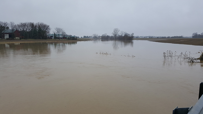
Forecasts are calling for rainfall totals between 15 and 25 mm over the next 24 hrs. Last week the region received around 15 mm of precipitation in the form of snow, much of which is still around waiting to melt. Temperatures are also expected to remain above freezing into Sunday.

A significant amount of rainfall in expected over the next 24 hrs. The warm temperatures and rain will also melt most of the snow lying around on the ground. This could lead to ponding and localized flooding in areas with poor drainage. Local ditches, creeks and streams will begin to rise later today and some could reach bank full conditions or spill their banks. The predicted rainfall combined with melting snow is likely to produce enough runoff that the McGregor Creek Diversion Channel will need to be operated.

The rain in the forecast could have a greater impact in shoreline areas. Due to the high lake levels, rainwater is not draining properly from these areas. In addition, any water from upstream making its way downstream on local watercourses into these shoreline areas could further impact these areas.

In order to reduce nuisance flooding, residents should ensure that catch basins and other drainage areas are clear of ice and debris.

People should take extra caution and avoid the river, ditches, and streams. The combination of slippery banks and fast moving cold water can be dangerous. Standing water can also present unseen hazards. Children and animals should be kept away from the water.

Officials will continue to monitor the situation and update this advisory if necessary.

This message will be in effect until January 26, 2020.

0
SHARES
ShareTweet

Font Size

Zoom in Regular Zoom out

Water Management

  • Flood Forecasting and Warning
  • LTVCA’s Flood Control Program
  • Water Control Structures
  • The History of Flooding
  • Flood Notices
  • Flood Notice Types
  • Water Levels
  • Harmful Algae Blooms

Flood Notice Archives

Downloads

  • Fee Schedule – Conservation Services
  • Personal Flood Emergency Plans

Recent Posts

  • Attention Sharon Creek Conservation Area Visitors!
  • LTVCA PARKING PASS EARTH DAY SPECIAL OFFER!
  • Shoreline Condition Statement – Flood Outlook – Standing Message – Lake Erie & Lake St. Clair – High Static Water Level – April 2021
  • Offices Closed Good Friday, Easter Monday

Upcoming Events

  • No events

Partner Links

  • Conservation Ontario
  • Thames-Sydenham & Region Source Protection Area
  • Thames River Clear Water Revival

Search


Chatham-Kent and Lambton Children's Water Festival


Canadian Heritage Rivers


A member of
Conservation Ontario

Copyright 2020 · Lower Thames Valley Conservation Authority
  • /Home
  • /Site Map
  • /Contact Us