• Home
  • About Us
    • Column 1
      • About the LTVCA
      • Budget and Financial Statements
      • Vision / Mission Statement
      • Board Packages and Minutes
      • Employment
      • Events
    • Column 2
      • FAQ’s
      • Volunteers
      • Fees & Publications
      • What’s New?
      • Public Social Media Policy
  • Programs
    • Planning and Regs
      • Plan Input and Review
      • Regulations
    • Water Management
      • Flood Forecasting and Warning
      • LTVCA’s Flood Control Program
      • Water Control Structures
      • The History of Flooding
      • Flood Notices
      • Flood Notice Types
      • Water Levels
    • Education & Outreach
      • Education Programs and Field Trips
      • Inclass and Virtual Programs
      • Professional Development
      • Ska-Nah-Doht Village & Museum
      • Habitat Fact Resources
    • Conservation Areas
      • Camping
      • Parking Passes
      • All Conservation Areas
    • Conservation Services
      • Tree Planting
      • Imagine McGregor
      • Grants for Landowners
      • Feature Partnership & Restoration Projects
      • Livestock Health
      • Lower Thames Soil Health Program 2022
      • Pollinator Habitats
      • Species at Risk
      • Invasive Species
      • McGregor and Jeannettes Creek Phosphorus Reduction Program
  • Foundation
    • Column 1
      • About the LTVC Foundation
      • Carey Carolinian Arboretum and Trail
      • Lower Thames Valley Conservation Foundation Bursary
      • Save the Cabins
    • Column 2
      • Memorial Forest Program
      • Fund-Raiser
      • Donate to Conservation
      • Volunteer Directors and Members
    • Column 3
      • Ontario Trillium Foundation Capital Grant for Wheelchair Accessible Boardwalk Replacement at Longwoods Road CA
      • Trillium ‘Seed’ Grant – Londwoods Feasibility Study 2018-2019
      • Conservation Foundation Privacy Policy
  • Contact Us
  • COVID-19 Update

Call us 519-354-7310

info@ltvca.ca
Lower Thames Valley Conservation AuthorityLower Thames Valley Conservation Authority
  • Home
  • About Us
    • Column 1
      • About the LTVCA
      • Budget and Financial Statements
      • Vision / Mission Statement
      • Board Packages and Minutes
      • Employment
      • Events
    • Column 2
      • FAQ’s
      • Volunteers
      • Fees & Publications
      • What’s New?
      • Public Social Media Policy
  • Programs
    • Planning and Regs
      • Plan Input and Review
      • Regulations
    • Water Management
      • Flood Forecasting and Warning
      • LTVCA’s Flood Control Program
      • Water Control Structures
      • The History of Flooding
      • Flood Notices
      • Flood Notice Types
      • Water Levels
    • Education & Outreach
      • Education Programs and Field Trips
      • Inclass and Virtual Programs
      • Professional Development
      • Ska-Nah-Doht Village & Museum
      • Habitat Fact Resources
    • Conservation Areas
      • Camping
      • Parking Passes
      • All Conservation Areas
    • Conservation Services
      • Tree Planting
      • Imagine McGregor
      • Grants for Landowners
      • Feature Partnership & Restoration Projects
      • Livestock Health
      • Lower Thames Soil Health Program 2022
      • Pollinator Habitats
      • Species at Risk
      • Invasive Species
      • McGregor and Jeannettes Creek Phosphorus Reduction Program
  • Foundation
    • Column 1
      • About the LTVC Foundation
      • Carey Carolinian Arboretum and Trail
      • Lower Thames Valley Conservation Foundation Bursary
      • Save the Cabins
    • Column 2
      • Memorial Forest Program
      • Fund-Raiser
      • Donate to Conservation
      • Volunteer Directors and Members
    • Column 3
      • Ontario Trillium Foundation Capital Grant for Wheelchair Accessible Boardwalk Replacement at Longwoods Road CA
      • Trillium ‘Seed’ Grant – Londwoods Feasibility Study 2018-2019
      • Conservation Foundation Privacy Policy
  • Contact Us
  • COVID-19 Update

The History of Flooding

Severe flooding throughout Ontario in the late 1930’s and early 1940’s led to the formation of the Conservation Authorities Act in 1946. Within the Lower Thames Valley Conservation Authority (LTVCA) watershed, flooding problems have frequently occurred. In the lower Thames River watershed, there are very large areas of floodplain beside the river.

These areas have historically been developed during periods of infrequent flooding and subsequently protected by diking during times of more frequent flooding. As upstream agricultural land use has gradually changed from general farming to a more cash crop intensive system, the speed of runoff water and the frequency of all degrees of flooding has increased. However, due to the topography of the lower Thames valley, the flooding is relatively shallow and of a low velocity. There are also lands within the LTVCA bordering on Lake Erie and Lake St. Clair which have been developed during periods of low lake levels and subsequently diked and drained during periods of higher lake levels. These areas are most prone to flooding during periods of high lake levels when winds generate high waves. Waves also quickly erode and breach the protective diking.

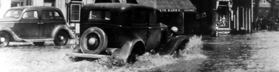
One of the prime initiatives behind the formation of the Lower Thames Valley Conservation Authority was to solve the flooding problem. Major flood events along the Thames River occurred in 1937 and 1947. These two almost identical flooding events  occurred as a result of heavy springtime rainfalls. These two floods were equivalent to floods, which should occur once every one hundred years. Since the Conservation Authority was formed in 1961 most of the major flood events of 1968, 1979 and 1985 have been associated with relatively high river flows and ice jams. Ice jam flooding affects large areas of agricultural land downstream of Chatham. The ice jam flood of 1985 inundated approximately 5600 hectares in four townships. The high lake level periods of 1973-1974 as well as 1985-1986 also produced flooding in lake abutting lands. The rapid rates of dike erosion as well as wave attack on homes during severe onshore winds are the main problems faced at these times.

Heavy rainfall, melting snow and river ice jams may cause water levels in streams and rivers to rise higher than the banks. Many low-lying areas along the lower Thames River and its major tributaries are especially prone to flooding.

Water Management

  • Flood Forecasting and Warning
  • LTVCA’s Flood Control Program
  • Water Control Structures
  • The History of Flooding
  • Flood Notices
  • Flood Notice Types
  • Water Levels

Flood Notice Archives

Downloads

  • Fee Schedule – Conservation Services
  • Personal Flood Emergency Plans
Find out more information about the LTVCA and COVID-19 COVID-19 Update

Facebook

What’s New?

  • Spring has Sprung! Big “O” Birding Event Held in Comber
  • Partners Celebrate Earth Day with LTVCA at Newly Restored Property in South Kent!
  • LTVCA’s Online Campground Reservations Are Live!
  • Bill 229 and Lower Thames Valley Conservation Authority – Inventory of Programs and Services
  • Media Release – Join Us for an Update by the Rondeau Barrier Beach and Navigation Channel Advisory Committee

Partner Links

  • Conservation Ontario
  • Thames-Sydenham & Region Source Protection Area
  • Thames River Clear Water Revival

Connect with us!

Search

© 2022 · Lower Thames Valley Conservation Authority |info@ltvca.ca | Tel: 519-354-7310

  • Home
  • Privacy
  • Contact Us