• Home
  • About Us
    • Column 1
      • About the LTVCA
      • Budget and Financial Statements
      • Vision / Mission Statement
      • Board Packages and Minutes
      • Employment
      • Events
    • Column 2
      • FAQ’s
      • Volunteers
      • Fees & Publications
      • What’s New?
      • Public Social Media Policy
  • Programs
    • Planning and Regs
      • Plan Input and Review
      • Regulations
    • Water Management
      • Flood Forecasting and Warning
      • LTVCA’s Flood Control Program
      • Water Control Structures
      • The History of Flooding
      • Flood Notices
      • Flood Notice Types
      • Water Levels
    • Education & Outreach
      • Education Programs and Field Trips
      • Inclass and Virtual Programs
      • Professional Development
      • Ska-Nah-Doht Village & Museum
      • Habitat Fact Resources
    • Conservation Areas
      • Camping
      • Parking Passes
      • All Conservation Areas
    • Conservation Services
      • Tree Planting
      • Imagine McGregor
      • Grants for Landowners
      • Feature Partnership & Restoration Projects
      • Livestock Health
      • Lower Thames Soil Health Program 2022
      • Pollinator Habitats
      • Species at Risk
      • Invasive Species
      • McGregor and Jeannettes Creek Phosphorus Reduction Program
  • Foundation
    • Column 1
      • About the LTVC Foundation
      • Carey Carolinian Arboretum and Trail
      • Lower Thames Valley Conservation Foundation Bursary
      • Save the Cabins
    • Column 2
      • Memorial Forest Program
      • Fund-Raiser
      • Donate to Conservation
      • Volunteer Directors and Members
    • Column 3
      • Ontario Trillium Foundation Capital Grant for Wheelchair Accessible Boardwalk Replacement at Longwoods Road CA
      • Trillium ‘Seed’ Grant – Londwoods Feasibility Study 2018-2019
      • Conservation Foundation Privacy Policy
  • Contact Us
  • Offices And Staff Have Returned to Regular Operations

Call us 519-354-7310

[email protected]
Lower Thames Valley Conservation AuthorityLower Thames Valley Conservation Authority
  • Home
  • About Us
    • Column 1
      • About the LTVCA
      • Budget and Financial Statements
      • Vision / Mission Statement
      • Board Packages and Minutes
      • Employment
      • Events
    • Column 2
      • FAQ’s
      • Volunteers
      • Fees & Publications
      • What’s New?
      • Public Social Media Policy
  • Programs
    • Planning and Regs
      • Plan Input and Review
      • Regulations
    • Water Management
      • Flood Forecasting and Warning
      • LTVCA’s Flood Control Program
      • Water Control Structures
      • The History of Flooding
      • Flood Notices
      • Flood Notice Types
      • Water Levels
    • Education & Outreach
      • Education Programs and Field Trips
      • Inclass and Virtual Programs
      • Professional Development
      • Ska-Nah-Doht Village & Museum
      • Habitat Fact Resources
    • Conservation Areas
      • Camping
      • Parking Passes
      • All Conservation Areas
    • Conservation Services
      • Tree Planting
      • Imagine McGregor
      • Grants for Landowners
      • Feature Partnership & Restoration Projects
      • Livestock Health
      • Lower Thames Soil Health Program 2022
      • Pollinator Habitats
      • Species at Risk
      • Invasive Species
      • McGregor and Jeannettes Creek Phosphorus Reduction Program
  • Foundation
    • Column 1
      • About the LTVC Foundation
      • Carey Carolinian Arboretum and Trail
      • Lower Thames Valley Conservation Foundation Bursary
      • Save the Cabins
    • Column 2
      • Memorial Forest Program
      • Fund-Raiser
      • Donate to Conservation
      • Volunteer Directors and Members
    • Column 3
      • Ontario Trillium Foundation Capital Grant for Wheelchair Accessible Boardwalk Replacement at Longwoods Road CA
      • Trillium ‘Seed’ Grant – Londwoods Feasibility Study 2018-2019
      • Conservation Foundation Privacy Policy
  • Contact Us
  • Offices And Staff Have Returned to Regular Operations

Watershed Conditions – Flood Outlook – Lake Erie Shoreline (all areas) – January 6, 2019 – 11:00 a.m.

Home Flood NoticesWatershed Conditions – Flood Outlook – Lake Erie Shoreline (all areas) – January 6, 2019 – 11:00 a.m.
Watershed Conditions – Flood Outlook – Lake Erie Shoreline (all areas) – January 6, 2019 – 11:00 a.m.

Watershed Conditions – Flood Outlook – Lake Erie Shoreline (all areas) – January 6, 2019 – 11:00 a.m.

January 6, 2019

Highlights:

•  Strong winds expected overnight tonight through Wednesday morning could cause issues along the Lake Erie shoreline.

•  Peak winds tomorrow evening of 45 km/hr with gusts of 70 km/hr and waves of 2 m.

•  Second period of peak winds Tuesday evening of 45 km/hr with gusts of 70 km/hr.

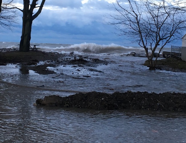
•  Potential for shoreline erosion and damage to shoreline protection works along the Lake Erie shoreline

•  Increased risk for Rose Beach Line overnight tonight and tomorrow morning.

•  Increased risk of wave spray flooding for Erie Shore Drive tomorrow afternoon through Tuesday afternoon.

•  Potential for freezing spray issues overnight tonight and tomorrow morning as well as Tues/Wed overnight.

Detailed Message

Weather forecasts are calling for strong winds beginning overnight tonight and lasting into the overnight period tomorrow.  After a brief reprieve, winds are expected to pick up again Tuesday afternoon with strong winds lasting into Thursday.  Forecasts are calling for sustained winds out of the east of 30 km/hr overnight tonight rising to over 40 km/hr by noon tomorrow.  During this period temperatures are expected to be just below freezing.  Winds are then expected to switch to a southerly direction, peaking tomorrow evening at speeds of over 45 km/hr from the south or southwest with gusts of 70 km/hr.  Waves are expected to reach 2m in height.  Winds are then expected to diminish to a southwesterly direction of less then 30 km/hr during the overnight period.  Tuesday afternoon, winds are expected to rise again over 30 km/hr from the southwest before switching to a more westerly direction, peaking in the evening at over 45 km/hr from the west with gusts of around 70 km/hr. Waves could be expected to reach 1.5 m in height.  Strong westerly winds over 35 km/hr are expected to last into Wednesday morning before shifting to a northwest direction when they will then have little impact on the shoreline.  During this overnight period temperatures are expect to be just below freezing.  Weather forecasts, especially wind forecasts, this early can change substantially, but the various forecasters are generally in agreement.

Strong winds will be driving waves onto our Lake Erie shoreline in Chatham-Kent and Elgin County starting this evening and lasting through Wednesday morning.  Throughout this entire period there is a risk that wave action could damage shoreline protection works and cause shoreline erosion. In flood prone areas, such as Erie Shore Drive, and some specific areas around Wheatley, there is a risk of flooding caused by waves crashing against the shoreline protection works and spraying water up onto the land. While temperatures are beneath freezing, overnight tonight and tomorrow morning, as well as the Tues/Wed overnight period, there is risk that this spray will freeze causing hazardous conditions.  While winds are out of the east and southeast direction, overnight tonight and into Tuesday, there is an increased risk for the Rose Beach Line area in Chatham-Kent as recently strong winds from that direction have caused erosion in the area and caused sand to block the outlets of creeks and municipal drainage leading to backup flooding.  As winds switch to a more southerly direction, tomorrow afternoon through Tuesday afternoon, the risk increases for the Erie Shore Drive area.  Blocked drainage outlets can also cause issues in this area as well. Residents along the Lake Erie shoreline should pay attention to weather forecasts as they could change and prepare accordingly.

People should take extra caution and avoid the shoreline should conditions get rough. The waves can be strong and the shoreline slippery. There could also be hazardous debris within the waves and water which could be thrown onto the shoreline. Freezing spray can also create slippery hazardous conditions, especially if it makes it to the roadways.  Standing water can also present unseen hazards. Children and pets should be kept away from the water. Officials will continue to monitor the situation and update this advisory if necessary.

Contact:  Jason Wintermute ([email protected]) (519-354-7310 x227) regarding this message.

This message will be in effect until January 10, 2019


Share
Find out more information about the LTVCA and COVID-19 COVID-19 Update

Facebook

What’s New?

  • Conservation Ontario Announces New General Manager
  • LTVCA Administration Office Closed Afternoon of Friday July 15, 2022
  • Happy Canada Day!
  • Field Trips Running Full Steam Ahead! Outdoor Education Programming Bustling Once Again at Ska-Nah-Doht Village and Longwoods Road Conservation Area!
  • Spring has Sprung! Big “O” Birding Event Held in Comber

Partner Links

  • Conservation Ontario
  • Thames-Sydenham & Region Source Protection Area
  • Thames River Clear Water Revival

Connect with us!

Search

© 2022 · Lower Thames Valley Conservation Authority |[email protected] | Tel: 519-354-7310

  • Home
  • Privacy
  • Contact Us
Prev Next