• Home
  • About Us
    • Governance
      • About the LTVCA
      • Board of Directors
      • Board Meetings
      • Budget & Financial Statements
      • Public Consultation & Bids
      • Reports/ Plans/ Fees / MOUs
    • Get Involved
      • Employment
      • Volunteers
      • FAQ’s
      • What’s New?
  • Visit
    • Get Outside
      • Conservation Areas
      • Camping
      • Parking Passes
      • Healthy Hikes
    • Things to Do
      • Events
      • Ska-Nah-Doht Village & Museum
  • Conservation
    • Water Management
      • Flood Forecasting & Warning
      • LTVCA’s Flood Control Program
      • Water Control Structures
      • The History of Flooding
      • Flood Notices
      • Flood Notice Types
      • Water Levels
    • Conservation Services
      • Tree Planting
      • Grants for Landowners
      • Feature Partnership & Restoration Projects
      • Phosphorus Education
      • Funding for Farmers
      • Species at Risk
      • Invasive Species
      • Pollinator Habitats
      • Livestock Health
      • LIVING LAB – ONTARIO
  • Learning
    • Education Programs
      • School & Community Groups
      • On-the-Road Programs
      • Asynchronous Opportunities
      • Habitat Fact Resources
  • Planning & Regulations
    • Planning and Regs
      • Plan Input & Review
      • Regulations
      • Enforcement & Compliance
      • Regulated Areas Map
  • Contact Us
    • Get In Touch
      • Contact Form
      • Enforcement & Compliance
      • Staff Directory

Call us 519-354-7310

[email protected]
Lower Thames Valley Conservation AuthorityLower Thames Valley Conservation Authority
  • Home
  • About Us
    • Governance
      • About the LTVCA
      • Board of Directors
      • Board Meetings
      • Budget & Financial Statements
      • Public Consultation & Bids
      • Reports/ Plans/ Fees / MOUs
    • Get Involved
      • Employment
      • Volunteers
      • FAQ’s
      • What’s New?
  • Visit
    • Get Outside
      • Conservation Areas
      • Camping
      • Parking Passes
      • Healthy Hikes
    • Things to Do
      • Events
      • Ska-Nah-Doht Village & Museum
  • Conservation
    • Water Management
      • Flood Forecasting & Warning
      • LTVCA’s Flood Control Program
      • Water Control Structures
      • The History of Flooding
      • Flood Notices
      • Flood Notice Types
      • Water Levels
    • Conservation Services
      • Tree Planting
      • Grants for Landowners
      • Feature Partnership & Restoration Projects
      • Phosphorus Education
      • Funding for Farmers
      • Species at Risk
      • Invasive Species
      • Pollinator Habitats
      • Livestock Health
      • LIVING LAB – ONTARIO
  • Learning
    • Education Programs
      • School & Community Groups
      • On-the-Road Programs
      • Asynchronous Opportunities
      • Habitat Fact Resources
  • Planning & Regulations
    • Planning and Regs
      • Plan Input & Review
      • Regulations
      • Enforcement & Compliance
      • Regulated Areas Map
  • Contact Us
    • Get In Touch
      • Contact Form
      • Enforcement & Compliance
      • Staff Directory

Safety Bulletin – Lake Erie Shoreline – Nov 30, 2018 @ 11:20 AM

Home » Safety Bulletin – Lake Erie Shoreline – Nov 30, 2018 @ 11:20 AM
Safety Bulletin – Lake Erie Shoreline – Nov 30, 2018 @ 11:20 AM

Safety Bulletin – Lake Erie Shoreline – Nov 30, 2018 @ 11:20 AM

November 30, 2018

Highlights:
• Strong winds out of the east and southeast on Saturday with a potential for strong winds out of the south on Sunday
• Potential for shoreline erosion, shoreline damage, flooding, and freezing spray

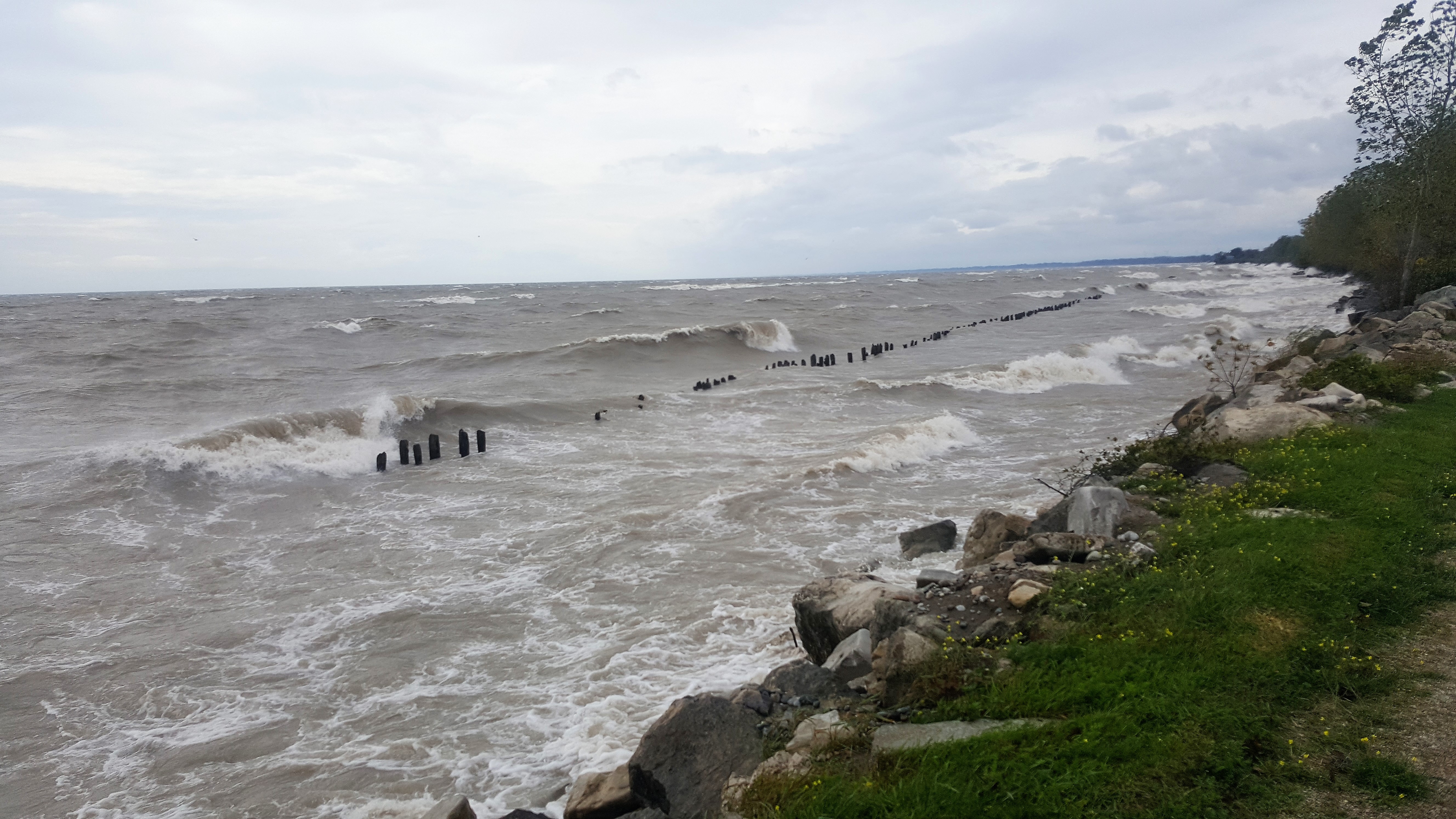
Environment Canada’s Marine Forecast has issued a Strong Wind Warning for Western Lake Erie. Weather forecasts are calling for winds exceeding 35 km/hour out of the east and southeast for most of Saturday. The peak sustained winds are currently expected to reach 42 km/hour around noon Saturday with gusts up to 63 km/hour. On Sunday, there is a chance that sustained wind speeds will fluctuate between 30 and 35 km/hour with gusts reaching up to 55 km/hour out of the south. The Marine Forecast is predicting that waves on Lake Erie may reach 1.5 m in height Saturday at noon.

While winds are out of the east and southeast on Saturday, there is the potential for shoreline impacts to the eastern side of Rondeau, including the Rose Beach Line area, as well as the Detroit Line area in Wheatley. There is a risk of erosion, damage to shoreline protection, and backup flooding from the various drain outlets in these stretches. Should the winds transition to the southeast and south, winds will be driving waves onto the whole length of our Lake Erie shoreline in Chatham-Kent and Elgin Counties. There is a risk that wave action could damage shoreline protection works, aggravate shoreline erosion, create flooding due to wave crashing against shoreline protection works along Erie Shore Drive, or create backup flooding from the various drain outlets in the Lake Erie shoreline stretch as well. Temperatures are predicted to be below freezing Saturday morning which creates the risk that wave spray or floodwaters could freeze creating hazardous conditions. Given the uncertainty around these forecasts, residents along the Lake Erie shoreline should pay close attention to both weather forecasts and current conditions and prepare accordingly.

People should take extra caution and avoid the shoreline should conditions get rough. The waves can be strong and the shoreline slippery. There could also be hazardous debris within the waves and water which could be thrown onto the shoreline. Standing water can also present unseen hazards. Children and pets should be kept away from the water. Officials will continue to monitor the situation and update this advisory if necessary.

Contact: Jason Homewood ([email protected]) or Jason Wintermute ([email protected]) regarding this message.

This message will be in effect until December 03, 2018.

Share

What’s New?

  • Watershed Condition Statement – Safety Bulletin – Thames River – April 7, 2025 – 12:00 PM
  • Flood Watch – Thames River and smaller watercourses – April 6, 2025 – 1:00 PM
  • Flood Watch – Thames River and smaller watercourses – April 5, 2025 – 9:00 AM
  • Flood Watch – Thames River and smaller watercourses – April 3, 2025 – 3:00 PM
  • Watershed Condition Statement – Flood Outlook – Smaller watercourses and Thames River – April 1, 2025 – 2:00 PM

Facebook

What’s New?

  • Breakfast & BMPs – Register Today!
  • NEW! Funding for Farmers – 2025 Guide and Application Form
  • Create Something this March Break
  • Battle of Longwoods Returns to Longwoods Road Conservation Area
  • Birding at Big ‘O’

Partner Links

  • Lower Thames Valley Conservation Foundation
  • Conservation Ontario
  • Thames Heritage River; Canadian Heritage Rivers System
  • Chatham-Kent and Lambton Children’s Water Festival
  • Thames-Sydenham & Region Source Protection Area
  • Thames River Clear Water Revival

Connect with us!

Search

© 2025 · Lower Thames Valley Conservation Authority |[email protected] | Tel: 519-354-7310

  • Home
  • Privacy
  • Public Social Media Policy
  • Contact Form
Prev Next