• Home
  • About Us
    • Governance
      • About the LTVCA
      • Board of Directors
      • Board Meetings
      • Budget & Financial Statements
      • Public Consultation & Bids
      • Reports/ Plans/ Fees / MOUs
    • Get Involved
      • Employment
      • Volunteers
      • FAQ’s
      • What’s New?
  • Visit
    • Get Outside
      • Conservation Areas
      • Camping
      • Parking Passes
      • Healthy Hikes
    • Things to Do
      • Events
      • Ska-Nah-Doht Village & Museum
  • Conservation
    • Water Management
      • Flood Forecasting & Warning
      • LTVCA’s Flood Control Program
      • Water Control Structures
      • The History of Flooding
      • Flood Notices
      • Flood Notice Types
      • Water Levels
    • Conservation Services
      • Tree Planting
      • Grants for Landowners
      • Feature Partnership & Restoration Projects
      • Phosphorus Education
      • Funding for Farmers
      • Species at Risk
      • Invasive Species
      • Pollinator Habitats
      • Livestock Health
      • LIVING LAB – ONTARIO
  • Learning
    • Education Programs
      • School & Community Groups
      • On-the-Road Programs
      • Asynchronous Opportunities
      • Habitat Fact Resources
  • Planning & Regulations
    • Planning and Regs
      • Plan Input & Review
      • Regulations
      • Enforcement & Compliance
      • Regulated Areas Map
  • Contact Us
    • Get In Touch
      • Contact Form
      • Enforcement & Compliance
      • Staff Directory

Call us 519-354-7310

[email protected]
Lower Thames Valley Conservation AuthorityLower Thames Valley Conservation Authority
  • Home
  • About Us
    • Governance
      • About the LTVCA
      • Board of Directors
      • Board Meetings
      • Budget & Financial Statements
      • Public Consultation & Bids
      • Reports/ Plans/ Fees / MOUs
    • Get Involved
      • Employment
      • Volunteers
      • FAQ’s
      • What’s New?
  • Visit
    • Get Outside
      • Conservation Areas
      • Camping
      • Parking Passes
      • Healthy Hikes
    • Things to Do
      • Events
      • Ska-Nah-Doht Village & Museum
  • Conservation
    • Water Management
      • Flood Forecasting & Warning
      • LTVCA’s Flood Control Program
      • Water Control Structures
      • The History of Flooding
      • Flood Notices
      • Flood Notice Types
      • Water Levels
    • Conservation Services
      • Tree Planting
      • Grants for Landowners
      • Feature Partnership & Restoration Projects
      • Phosphorus Education
      • Funding for Farmers
      • Species at Risk
      • Invasive Species
      • Pollinator Habitats
      • Livestock Health
      • LIVING LAB – ONTARIO
  • Learning
    • Education Programs
      • School & Community Groups
      • On-the-Road Programs
      • Asynchronous Opportunities
      • Habitat Fact Resources
  • Planning & Regulations
    • Planning and Regs
      • Plan Input & Review
      • Regulations
      • Enforcement & Compliance
      • Regulated Areas Map
  • Contact Us
    • Get In Touch
      • Contact Form
      • Enforcement & Compliance
      • Staff Directory

Watershed Conditions – Safety Bulletin – Thames River Watershed – March 11, 2019 – 12:30 p.m.

Home » Watershed Conditions – Safety Bulletin – Thames River Watershed – March 11, 2019 – 12:30 p.m.
Watershed Conditions – Safety Bulletin – Thames River Watershed – March 11, 2019 – 12:30 p.m.

Watershed Conditions – Safety Bulletin – Thames River Watershed – March 11, 2019 – 12:30 p.m.

March 11, 2019

Highlights:

• Water levels on local ditches, creeks and streams are falling after this weekend’s rain.
• Thames River has lost its ice cover downstream as far as Kent Bridge.
• Water levels on the Thames River are expected to rise further later in the week.

Message:

Over the weekend, the Thames River watershed received only 5 to 15 mm of rainfall (about half of what was predicted). Over the next couple of days, temperatures are expected to be above freezing during the day and below freezing at night. Then beginning Wednesday temperatures will climb and not fall below freezing again until Friday night. Thursday’s forecast is calling for a spike in temperatures, possible reaching 15 ֯C, with 5 to 10 mm of rain.

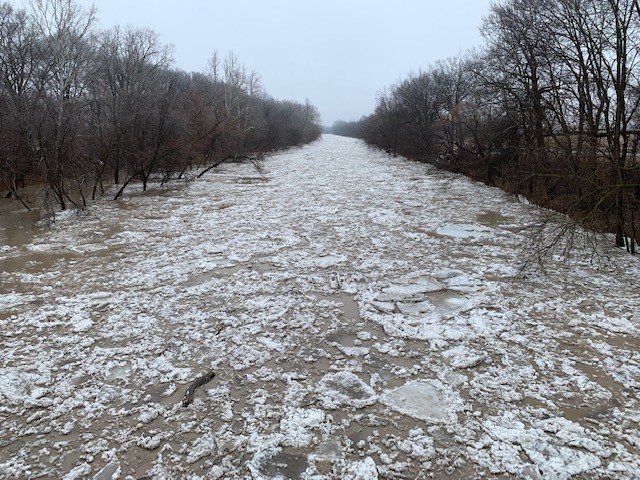
Freezing temperatures over the last couple of weeks had left the Thames River with about 5 to 10 cm of ice thickness (about half the ice thickness the river had before the ice jam occurred in February). That ice has now started to melt out and break up. The ice cover has mostly disappeared on the Thames River in Chatham-Kent from its eastern boundary down to Kent Bridge. However, flows in the river are relatively low and it’s not certain how far downstream from there that the river might break up. Lake St. Clair is currently open in the immediate area around the mouth of the Thames River. There appears to be little risk currently of an ice jam forming, but conditions will need to be monitored as the week progresses.

Water levels on the local ditches, creeks and streams have now peaked from this weekend’s rainfall and are now dropping. There is very little snow left in the Lower Thames watershed and what remains should melt out over the next few days.

The snowpack in the Upper Thames watershed has not yet melted out as much as it has in the Lower Thames. Over the next couple of days, water levels on the river are not expected to rise up into the flood flats. However, the warmup and rainfall in the latter half of the week could cause water levels to rise more rapidly and even higher.

People should take extra caution and avoid the river, ditches, and streams. The combination of slippery banks, broken or unstable ice and fast moving cold water can be dangerous. Any remaining ice cover on the river is not safe to be out on. Children and animals should be kept away from the water.

Officials will continue to monitor the situation and update this advisory if necessary.

This message will be in effect until March 14th, 2019.

Contact: Contact: Jason Wintermute (519-354-7310 x227, [email protected]) regarding this message.

Share

What’s New?

  • Watershed Condition Statement – Safety Bulletin – Thames River – April 7, 2025 – 12:00 PM
  • Flood Watch – Thames River and smaller watercourses – April 6, 2025 – 1:00 PM
  • Flood Watch – Thames River and smaller watercourses – April 5, 2025 – 9:00 AM
  • Flood Watch – Thames River and smaller watercourses – April 3, 2025 – 3:00 PM
  • Watershed Condition Statement – Flood Outlook – Smaller watercourses and Thames River – April 1, 2025 – 2:00 PM

Facebook

What’s New?

  • Breakfast & BMPs – Register Today!
  • NEW! Funding for Farmers – 2025 Guide and Application Form
  • Create Something this March Break
  • Battle of Longwoods Returns to Longwoods Road Conservation Area
  • Birding at Big ‘O’

Partner Links

  • Lower Thames Valley Conservation Foundation
  • Conservation Ontario
  • Thames Heritage River; Canadian Heritage Rivers System
  • Chatham-Kent and Lambton Children’s Water Festival
  • Thames-Sydenham & Region Source Protection Area
  • Thames River Clear Water Revival

Connect with us!

Search

© 2025 · Lower Thames Valley Conservation Authority |[email protected] | Tel: 519-354-7310

  • Home
  • Privacy
  • Public Social Media Policy
  • Contact Form
Prev Next