• Home
  • About Us
    • Governance
      • About the LTVCA
      • Board of Directors
      • Board Meetings
      • Budget & Financial Statements
      • Public Consultation & Bids
      • Reports/ Plans/ Fees / MOUs
    • Get Involved
      • Employment
      • Volunteers
      • FAQ’s
      • What’s New?
  • Visit
    • Get Outside
      • Conservation Areas
      • Camping
      • Parking Passes
      • Healthy Hikes
    • Things to Do
      • Events
      • Ska-Nah-Doht Village & Museum
  • Conservation
    • Water Management
      • Flood Forecasting & Warning
      • LTVCA’s Flood Control Program
      • Water Control Structures
      • The History of Flooding
      • Flood Notices
      • Flood Notice Types
      • Water Levels
    • Conservation Services
      • Tree Planting
      • Grants for Landowners
      • Feature Partnership & Restoration Projects
      • Phosphorus Education
      • Funding for Farmers
      • Species at Risk
      • Invasive Species
      • Pollinator Habitats
      • Livestock Health
      • LIVING LAB – ONTARIO
  • Learning
    • Education Programs
      • School & Community Groups
      • On-the-Road Programs
      • Asynchronous Opportunities
      • Habitat Fact Resources
  • Planning & Regulations
    • Planning and Regs
      • Plan Input & Review
      • Regulations
      • Enforcement & Compliance
      • Regulated Areas Map
  • Contact Us
    • Get In Touch
      • Contact Form
      • Enforcement & Compliance
      • Staff Directory

Call us 519-354-7310

[email protected]
Lower Thames Valley Conservation AuthorityLower Thames Valley Conservation Authority
  • Home
  • About Us
    • Governance
      • About the LTVCA
      • Board of Directors
      • Board Meetings
      • Budget & Financial Statements
      • Public Consultation & Bids
      • Reports/ Plans/ Fees / MOUs
    • Get Involved
      • Employment
      • Volunteers
      • FAQ’s
      • What’s New?
  • Visit
    • Get Outside
      • Conservation Areas
      • Camping
      • Parking Passes
      • Healthy Hikes
    • Things to Do
      • Events
      • Ska-Nah-Doht Village & Museum
  • Conservation
    • Water Management
      • Flood Forecasting & Warning
      • LTVCA’s Flood Control Program
      • Water Control Structures
      • The History of Flooding
      • Flood Notices
      • Flood Notice Types
      • Water Levels
    • Conservation Services
      • Tree Planting
      • Grants for Landowners
      • Feature Partnership & Restoration Projects
      • Phosphorus Education
      • Funding for Farmers
      • Species at Risk
      • Invasive Species
      • Pollinator Habitats
      • Livestock Health
      • LIVING LAB – ONTARIO
  • Learning
    • Education Programs
      • School & Community Groups
      • On-the-Road Programs
      • Asynchronous Opportunities
      • Habitat Fact Resources
  • Planning & Regulations
    • Planning and Regs
      • Plan Input & Review
      • Regulations
      • Enforcement & Compliance
      • Regulated Areas Map
  • Contact Us
    • Get In Touch
      • Contact Form
      • Enforcement & Compliance
      • Staff Directory

Watershed Conditions – Safety Bulletin – Thames River Watershed – February 23, 2019 – 1:15 p.m.

Home » Watershed Conditions – Safety Bulletin – Thames River Watershed – February 23, 2019 – 1:15 p.m.
Watershed Conditions – Safety Bulletin – Thames River Watershed – February 23, 2019 – 1:15 p.m.

Watershed Conditions – Safety Bulletin – Thames River Watershed – February 23, 2019 – 1:15 p.m.

February 23, 2019

Highlights:

• Warm temperatures and rain over the next couple of days will cause water levels to rise.
• Possible flooding in low lying areas or on local watercourses where ice and snow create blockages
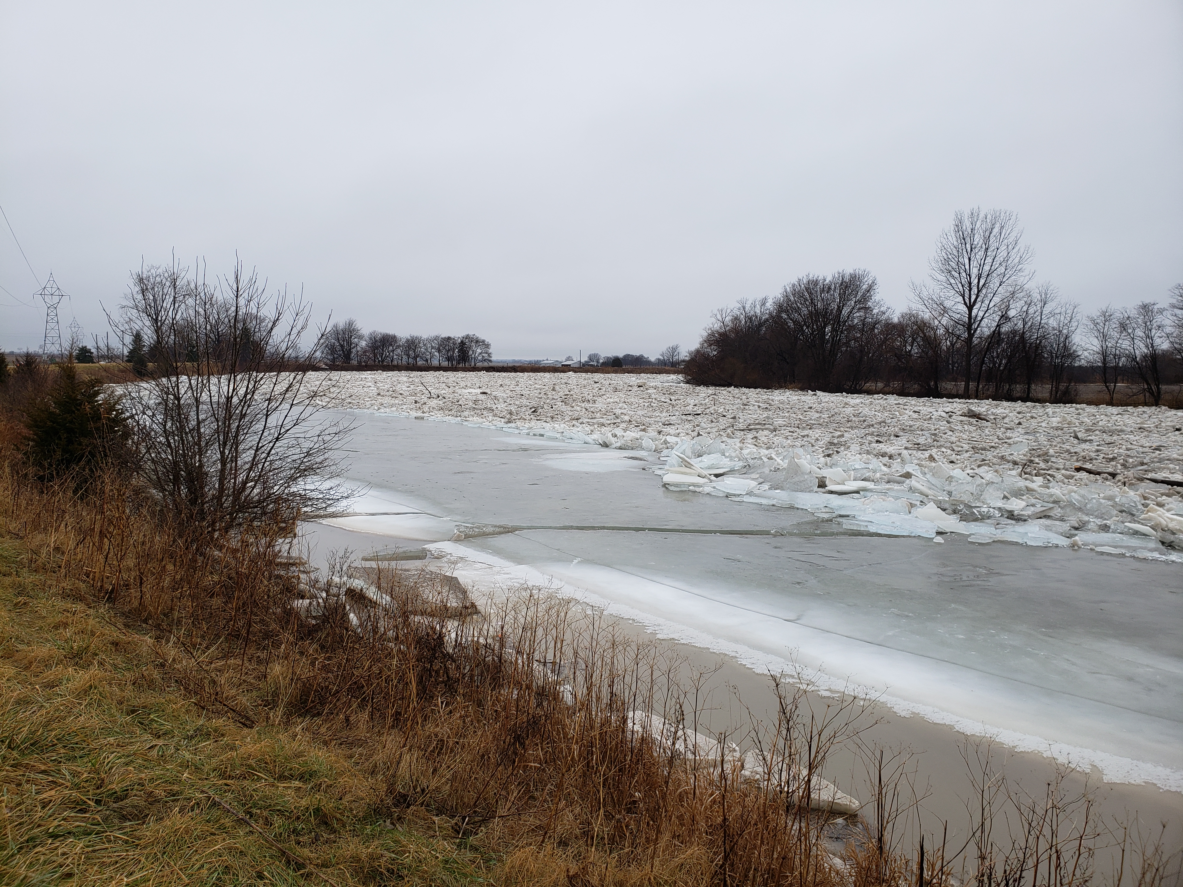
• The ice jam at Lighthouse Cove could mobilize. However, based on historical ice jams, it does not appear that there would be enough flow in the river to cause flooding, at least over the next few days.

Message:

The ice jam that formed earlier this month on the Thames River near the mouth at Lighthouse Cove remains in place. Ice on Lake St. Clair also remains in place around the mouth of the Thames River. The Lower Thames River appears largely ice free throughout Chatham-Kent down though Prairie Siding to the upstream end of the ice jam. In the Lower Thames watershed, weather forecasts are calling for 5-10 mm of rainfall this afternoon through tomorrow afternoon with temperatures remaining above freezing until tomorrow evening. In the Upper Thames watershed, forecasts are calling for similar temperatures and up to 15 mm of rain. In the Upper Thames watershed there is also an additional 40-50 mm of water stored in the snowpack that could be released.

Based on current forecasts, smaller local watercourses can be expected to rise but are not expected to reach bank full conditions. However, blockages due to ice and snow could create localized flooding.

Water levels can also be expected to rise on the Thames River. It is possible that water levels may raise high enough to flood the most low lying river flats from Delaware down to Chatham. That will depend on how much rainfall and snowmelt occurs. It is possible that the ice jam located at Lighthouse Cove could mobilize in the coming days. However, based on the local weather forecasts and the behavior of historical ice jams, it does not appear that there would be enough flow in the river to cause further flooding over the next few days. Flows coming out of the Upper Thames watershed as it melts would be expected to arrive in the area of the ice jam mid-week. It’s difficult to say this early what the impact of those flows may be.

People should take extra caution and avoid the river, creeks, ditches and streams. The combination of slippery banks and fast moving water can be dangerous. Standing water can also present its own unseen hazards. Children and animals should be kept away from the water.

Officials will continue to monitor the situation and update this advisory if necessary.

This message will be in effect until February 25th, 2019.

Contact: Jason Wintermute ([email protected]) regarding this message.

Share

What’s New?

  • Watershed Condition Statement – Safety Bulletin – Thames River – April 7, 2025 – 12:00 PM
  • Flood Watch – Thames River and smaller watercourses – April 6, 2025 – 1:00 PM
  • Flood Watch – Thames River and smaller watercourses – April 5, 2025 – 9:00 AM
  • Flood Watch – Thames River and smaller watercourses – April 3, 2025 – 3:00 PM
  • Watershed Condition Statement – Flood Outlook – Smaller watercourses and Thames River – April 1, 2025 – 2:00 PM

Facebook

What’s New?

  • Breakfast & BMPs – Register Today!
  • NEW! Funding for Farmers – 2025 Guide and Application Form
  • Create Something this March Break
  • Battle of Longwoods Returns to Longwoods Road Conservation Area
  • Birding at Big ‘O’

Partner Links

  • Lower Thames Valley Conservation Foundation
  • Conservation Ontario
  • Thames Heritage River; Canadian Heritage Rivers System
  • Chatham-Kent and Lambton Children’s Water Festival
  • Thames-Sydenham & Region Source Protection Area
  • Thames River Clear Water Revival

Connect with us!

Search

© 2025 · Lower Thames Valley Conservation Authority |[email protected] | Tel: 519-354-7310

  • Home
  • Privacy
  • Public Social Media Policy
  • Contact Form
Prev Next