• Home
  • About Us
    • Governance
      • About the LTVCA
      • Board of Directors
      • Board Meetings
      • Budget & Financial Statements
      • Public Consultation & Bids
      • Reports/ Plans/ Fees / MOUs
    • Get Involved
      • Employment
      • Volunteers
      • FAQ’s
      • What’s New?
  • Visit
    • Get Outside
      • Conservation Areas
      • Camping
      • Parking Passes
      • Healthy Hikes
    • Things to Do
      • Events
      • Ska-Nah-Doht Village & Museum
  • Conservation
    • Water Management
      • Flood Forecasting & Warning
      • LTVCA’s Flood Control Program
      • Water Control Structures
      • The History of Flooding
      • Flood Notices
      • Flood Notice Types
      • Water Levels
    • Conservation Services
      • Tree Planting
      • Grants for Landowners
      • Feature Partnership & Restoration Projects
      • Phosphorus Education
      • Funding for Farmers
      • Species at Risk
      • Invasive Species
      • Pollinator Habitats
      • Livestock Health
      • LIVING LAB – ONTARIO
  • Learning
    • Education Programs
      • School & Community Groups
      • On-the-Road Programs
      • Asynchronous Opportunities
      • Habitat Fact Resources
  • Planning & Regulations
    • Planning and Regs
      • Plan Input & Review
      • Regulations
      • Enforcement & Compliance
      • Regulated Areas Map
  • Contact Us
    • Get In Touch
      • Contact Form
      • Enforcement & Compliance
      • Staff Directory

Call us 519-354-7310

[email protected]
Lower Thames Valley Conservation AuthorityLower Thames Valley Conservation Authority
  • Home
  • About Us
    • Governance
      • About the LTVCA
      • Board of Directors
      • Board Meetings
      • Budget & Financial Statements
      • Public Consultation & Bids
      • Reports/ Plans/ Fees / MOUs
    • Get Involved
      • Employment
      • Volunteers
      • FAQ’s
      • What’s New?
  • Visit
    • Get Outside
      • Conservation Areas
      • Camping
      • Parking Passes
      • Healthy Hikes
    • Things to Do
      • Events
      • Ska-Nah-Doht Village & Museum
  • Conservation
    • Water Management
      • Flood Forecasting & Warning
      • LTVCA’s Flood Control Program
      • Water Control Structures
      • The History of Flooding
      • Flood Notices
      • Flood Notice Types
      • Water Levels
    • Conservation Services
      • Tree Planting
      • Grants for Landowners
      • Feature Partnership & Restoration Projects
      • Phosphorus Education
      • Funding for Farmers
      • Species at Risk
      • Invasive Species
      • Pollinator Habitats
      • Livestock Health
      • LIVING LAB – ONTARIO
  • Learning
    • Education Programs
      • School & Community Groups
      • On-the-Road Programs
      • Asynchronous Opportunities
      • Habitat Fact Resources
  • Planning & Regulations
    • Planning and Regs
      • Plan Input & Review
      • Regulations
      • Enforcement & Compliance
      • Regulated Areas Map
  • Contact Us
    • Get In Touch
      • Contact Form
      • Enforcement & Compliance
      • Staff Directory

Watershed Conditions – Flood Outlook – All Areas – April 16th, 2018 – 11:00 AM

Home » Watershed Conditions – Flood Outlook – All Areas – April 16th, 2018 – 11:00 AM
Watershed Conditions – Flood Outlook – All Areas – April 16th, 2018 – 11:00 AM

Watershed Conditions – Flood Outlook – All Areas – April 16th, 2018 – 11:00 AM

April 16, 2018

The Lower Thames watershed received between 10 and 20 mm of rainfall on Saturday and between 40 and 50 mm yesterday. However, some areas may have received more due to thunderstorm activity. Weather forecasts are calling for an additional 5 – 10 mm of rainfall on Wednesday. Over the last few days there have been strong winds out of the north and east. Winds have now switched to the west and are expected to switch to the southwest this afternoon at sustained wind speeds between 35 and 45 km/hr. Environment Canada’s Marine Forecast suggests winds over Lake Erie could reach 55 km/hr and wave heights are expected to reach 2m this afternoon.

Shoreline areas around Rondeau Bay, including Shrewsbury, Erie Shore Drive, Rose Beach Line and Erieau experienced flooding due to the strong north and east winds over the weekend. Now that the winds have switched to the southwest, most of these areas should be able to recover. However, Erie Shore Drive in Chatham-Kent has been experiencing flooding when there are sustained winds above 35 km/hr from a southerly direction (southeast through southwest). Therefore, the forecasted wind speeds and direction are expected to cause flooding along Erie Shore Drive again this afternoon. While winds remain from the south and southwest, the waves will be driving onto our Lake Erie Shoreline in Chatham-Kent and Elgin County. There is also a risk that wave action could damage shoreline protection works and cause shoreline erosion.

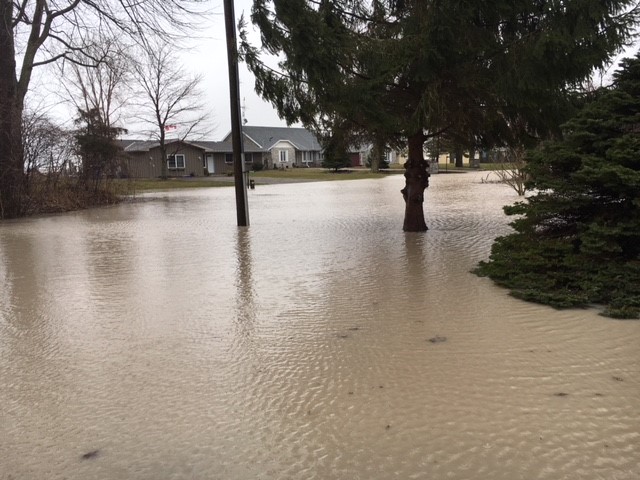
Throughout the watershed, the weekend’s rainfall has caused water levels to rise on many of the region’s smaller local watercourses and many spilled their banks. Early yesterday evening, the LTVCA began operation of the McGregor Creek Diversion Channel to protect the south end of the City of Chatham from flooding. Water levels have now peaked on most of these watercourses and are now dropping.

Water levels on the Thames River will also rise in response to the rainfall. Water levels on the river are expected to remain high most of next week as the water makes its way downstream. Upstream areas of the Lower Thames are expected to see peak river levels early tomorrow morning. The river will rise and flood the low-lying flats adjacent to the river from Delaware down to Chatham. At this time, a more normal spring event is anticipated. Although it’s difficult to be accurate this early out, water levels in Chatham are expected to rise and flood the sidewalk along the river in downtown Chatham and perhaps the road under the 5th St. Bridge. Basement flooding is not expected along King St and the LTVCA does not expect to have to operate the 6th Street Backwater Dam and Pumping Station.

People should take extra caution and avoid the shoreline, river, ditches, and streams. On watercourses, the combination of slippery banks and fast moving cold water can be dangerous. Shorelines can be slippery and waves can be strong. There could also be hazardous debris within the waves and water. Standing water can also present its own unseen hazards. Children and pets should be kept away from the water.

Officials will continue to monitor the situation and update this advisory if necessary.
This message will be in effect until April 17th, 2018.

Contact: Jason Wintermute ([email protected],), 519-354-7310 x227) regarding this message.

Share

What’s New?

  • Watershed Condition Statement – Safety Bulletin – Thames River – April 7, 2025 – 12:00 PM
  • Flood Watch – Thames River and smaller watercourses – April 6, 2025 – 1:00 PM
  • Flood Watch – Thames River and smaller watercourses – April 5, 2025 – 9:00 AM
  • Flood Watch – Thames River and smaller watercourses – April 3, 2025 – 3:00 PM
  • Watershed Condition Statement – Flood Outlook – Smaller watercourses and Thames River – April 1, 2025 – 2:00 PM

Facebook

What’s New?

  • Breakfast & BMPs – Register Today!
  • NEW! Funding for Farmers – 2025 Guide and Application Form
  • Create Something this March Break
  • Battle of Longwoods Returns to Longwoods Road Conservation Area
  • Birding at Big ‘O’

Partner Links

  • Lower Thames Valley Conservation Foundation
  • Conservation Ontario
  • Thames Heritage River; Canadian Heritage Rivers System
  • Chatham-Kent and Lambton Children’s Water Festival
  • Thames-Sydenham & Region Source Protection Area
  • Thames River Clear Water Revival

Connect with us!

Search

© 2025 · Lower Thames Valley Conservation Authority |[email protected] | Tel: 519-354-7310

  • Home
  • Privacy
  • Public Social Media Policy
  • Contact Form
Prev Next