Operation and Maintenance – Dams, Dikes and Diversion Channels …
Water Control Structures to Protect You
The Lower Thames River has a long history of flooding. The LTVCA has developed the expertise and understanding of the geography of the region, the nuances of the Thames River and its reaction to natural or man-made interference. In fact, one of the primary reasons for the founding of the LTVCA was to provide a coordinated response to the flood problem. The most visible works of the LTVCA, including diking and diversion channels, revolve around the flooding problem. The operation of water control structures helps to ensure a coordinated response to flooding problems.
The Lower Thames Valley Conservation Authority operates and maintains Conservation Authority owned water control structure, primarily the Indian/McGregor Flood Control Project.
Select an item below for more information.
The Indian and McGregor Creek watersheds drain over 27,000 hectares of land in the southern area of the Municipality of Chatham-Kent, making it one of the largest watersheds within the LTVCA’s jurisdiction. The McGregor Creek has its headwaters in the village of Highgate and the town of Ridgetown. It flows generally west through the previously named townships of Orford, Howard and Harwich until it reaches Kent Centre, where it flows north to Chatham. The Indian Creek flows north from Blenheim through the previously named Raleigh Township to the outskirts of Chatham. It then flows east to join with the McGregor Creek.
Flooding first became an issue in the early 1900’s, with runoff and backup flooding from both creeks affecting the Municipality of Chatham-Kent. Runoff flooding occurs as a result of heavy rainfall, sometimes accompanied by melting snow. It has increased over the years due to the loss of forests, changes in farming operations and improved drainage practices. Backup flooding results when significant runoff in the Thames River watershed reached Chatham. The water levels rise and ‘backup’ through the McGregor Creek, submerging the same flood prone area. One of the most vulnerable flood-prone areas is along Indian Creek in Chatham and surrounding areas in the previously named Townships of Harwich and Raleigh. Both runoff and backup flooding affect these areas. Under runoff conditions, flows on McGregor Creek are high enough to backup Indian Creek and flood a large, urban area. Channel restrictions on McGregor Creek in Chatham also reduced the capacity for flow in the creek. The Indian / McGregor Creek Flood Control Project is designed to reduce flood risk in south Chatham and the surrounding areas of the previously named Harwich and Raleigh Townships, and to provide an adequate outlet for the McGregor watershed.
The Indian/McGregor Creek Flood Control Project was initiated in 1968 to deal with this recurring problem. Following a four-year investigation, construction began to improve the outlet capabilities of the Indian and McGregor Creeks. However, these improvements were insufficient in handling excessive runoff flows and in 1984, the project became the subject of an Environmental Assessment. The Assessment’s purpose was to determine the best possible location for a diversion channel to handle the high runoff flows. An upstream location was selected to divert a majority of McGregor Creek’s water flow through high land.
In 1989, after an agreement was made with the eight municipalities concerning cost distribution, funding was received from the Province of Ontario, and construction began. The 3.3 km long channel which borders the eastern boundary of Chatham was completed in 1991. A backwater control and pumping station, situated near the mouth of the McGregor Creek, achieved completion the following year.
The final cost of the Indian/McGregor Creek Flood Control Project was 16.2 million dollars. This sum was 10 percent below the amount budgeted. Subsequently, the Municipality of Chatham-Kent will experience over 30 million dollars worth of benefits and possible flood damage to 2,000 homes and businesses has been eliminated.
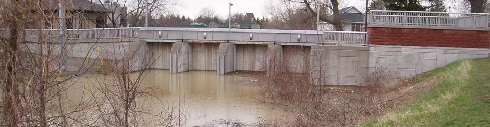
A major project component is a diversion channel, 3.3 km in length, generally located along the eastern boundary of Chatham. This channel has a top width of about 50 m and depth of approximately 6 m. A gated inlet structure is located on McGregor Creek at the entrance to the diversion channel. This inlet structure contains gates, which close under runoff conditions on McGregor Creek. Closing the gates forces runoff water from the McGregor Creek down the diversion channel. Under normal flow conditions, the gates are open and allow these flows to go down McGregor Creek. The diversion channel is grass lined and dry throughout the year except during flood periods. Halfway along the channel is a 12 hectare disposal site, a parcel of land containing excavated material from the channel. The diversion channel, completed in 1991, cost $11.1 million.
The backwater control dam and pumping station are situated near the mouth of McGregor Creek. The backwater control dam has 4 gates, each measuring 3 m by 5 m. The gates are only closed when water in the Thames River is high. This prevents Thames River water from backing up into the flood prone area. The pumping station, which is adjacent to the backwater control dam, houses a battery of submersed electric pumps. When the gates on the backwater control dam are closed, these pumps force nominal drainage water from the Indian Creek over the dam and into the swollen river. The pumping station has the capacity to pump 8.5 cubic m of water per second. The back water control dam and pumping station were completed in 1992 at a cost of $2.7 million.
Improvements to upstream sections of Indian Creek, Gregory Drain and McGregor Creek bring these channels to a consistent and acceptable capacity for runoff. Enlargement of the culvert on Indian Creek at Queen St. and improvements to the McGeachy Farm bridge were completed in 1993. Including the improvements to the upstream section of the McGregor Creek, the cost of these other project components is $2.5 million.
From a low cycle in 1964, Lake St. Clair rose to record heights in 1973 resulting in many emergency diking and excavation projects to hold back Lake St. Clair from the Thames River to the Sydenham River. Recognizing the problem, the Province of Ontario and the Federal Government undertook a joint diking program in the mid to late 1970’s. During this time in the Lower Thames Valley Conservation Authority, approximately 56 kilometres of dikes were constructed to protect low lying farmland. The total cost of these projects during this era was $10 million.