• Home
  • About Us
    • Governance
      • About the LTVCA
      • Board of Directors
      • Board Meetings
      • Budget & Financial Statements
      • Public Consultation & Bids
      • Reports/ Plans/ Fees / MOUs
    • Get Involved
      • Employment
      • Volunteers
      • FAQ’s
      • What’s New?
  • Visit
    • Get Outside
      • Conservation Areas
      • Camping
      • Parking Passes
      • Healthy Hikes
    • Things to Do
      • Events
      • Ska-Nah-Doht Village & Museum
  • Conservation
    • Water Management
      • Flood Forecasting & Warning
      • LTVCA’s Flood Control Program
      • Water Control Structures
      • The History of Flooding
      • Flood Notices
      • Flood Notice Types
      • Water Levels
    • Conservation Services
      • Tree Planting
      • Grants for Landowners
      • Feature Partnership & Restoration Projects
      • Phosphorus Education
      • Funding for Farmers
      • Species at Risk
      • Invasive Species
      • Pollinator Habitats
      • Livestock Health
      • LIVING LAB – ONTARIO
  • Learning
    • Education Programs
      • School & Community Groups
      • On-the-Road Programs
      • Asynchronous Opportunities
      • Habitat Fact Resources
  • Planning & Regulations
    • Planning and Regs
      • Plan Input & Review
      • Regulations
      • Enforcement & Compliance
      • Regulated Areas Map
  • Contact Us
    • Get In Touch
      • Contact Form
      • Enforcement & Compliance
      • Staff Directory

Call us 519-354-7310

[email protected]
Lower Thames Valley Conservation AuthorityLower Thames Valley Conservation Authority
  • Home
  • About Us
    • Governance
      • About the LTVCA
      • Board of Directors
      • Board Meetings
      • Budget & Financial Statements
      • Public Consultation & Bids
      • Reports/ Plans/ Fees / MOUs
    • Get Involved
      • Employment
      • Volunteers
      • FAQ’s
      • What’s New?
  • Visit
    • Get Outside
      • Conservation Areas
      • Camping
      • Parking Passes
      • Healthy Hikes
    • Things to Do
      • Events
      • Ska-Nah-Doht Village & Museum
  • Conservation
    • Water Management
      • Flood Forecasting & Warning
      • LTVCA’s Flood Control Program
      • Water Control Structures
      • The History of Flooding
      • Flood Notices
      • Flood Notice Types
      • Water Levels
    • Conservation Services
      • Tree Planting
      • Grants for Landowners
      • Feature Partnership & Restoration Projects
      • Phosphorus Education
      • Funding for Farmers
      • Species at Risk
      • Invasive Species
      • Pollinator Habitats
      • Livestock Health
      • LIVING LAB – ONTARIO
  • Learning
    • Education Programs
      • School & Community Groups
      • On-the-Road Programs
      • Asynchronous Opportunities
      • Habitat Fact Resources
  • Planning & Regulations
    • Planning and Regs
      • Plan Input & Review
      • Regulations
      • Enforcement & Compliance
      • Regulated Areas Map
  • Contact Us
    • Get In Touch
      • Contact Form
      • Enforcement & Compliance
      • Staff Directory

Flood Notice Types

Home » Water Management » Flood Forecasting and Warning » Flood Notice Types

Flooding is a natural process. While the Authority has done much to reduce the risk to life and property, some flooding in developed areas is still inevitable. The Authority, therefore, operates a flood warning program designed to warn residents in flood-prone areas. Through a network of 11 stream gauges, five snow sampling stations, ice monitoring, and current meteorological data, Authority staff monitor stream flow conditions. Should a flood be imminent, the Municipal Flood Coordinators and the media are contacted and officials take appropriate action.

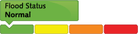
Five Types of Notices Sent to the Media and Municipalities Depending on Watershed Conditions

Flood Status Normal

Flood Status Water Safety

High flows, unsafe banks, melting ice or other factors that could be dangerous for recreational users such as anglers, canoeists, hikers, children, pets, etc. Flooding is not expected.

Flood Status Flood Outlook

Early notice of the potential for flooding based on weather forecasts calling for heavy rain, snow melt, high wind or other conditions that could lead to high runoff, cause ice jams, lakeshore flooding or erosion.

Flood Status Flood Watch

Flooding is possible in specific watercourses or municipalities. Municipalities, emergency services, and individual landowners in flood-prone areas should prepare.

Flood Status Flood Warning

Flooding is imminent or already occurring in specific watercourses or municipalities.


Standardized Flood Messages for the Great Lakes – Update Related to Shoreline Conditions Statement

In Ontario, Flood Forecasting and Warning is coordinated across the province. The Surface Water Monitoring Centre provides a provincial scale assessment of flood potential and issues provincial flood messages. Conservation Authorities (CAs), and Ministry of Natural Resources and Forestry Districts where CAs don’t exist, provide a local scale assessment of flood potential and issue local flood messages. To ensure that flood messages use consistent terminology and intent everywhere in Ontario, standard message types, descriptions, and graphics were established many years ago.  Messages are to contain information such as date and time of issue, expiry dates, versioning number, contact information, weather forecast/outlook, implications and recommended actions. Ensuring messages contain all essential information means that the recipients receive consistent messages and it also supports multi agency tracking, updating and mapping of flood risk in Ontario.

Over the last several years, record-high water levels on the Great Lakes, have posed new challenges for the flood forecasting community. One challenge has been applying standard flood message types to the Great Lakes. The existing flood message types didn’t adequately represent the flood risks on the Great Lakes (erosion, waves, shoreline inundation).  This gap in the standard flood message types led to local agencies creating new and/or ad- hoc flood message titles to reflect their local situation.  In response, the Provincial Flood Forecasting and Warning Committee drafted two proposed adaptations to current flood messaging which would support continued consistency.  The first was to discontinue the use of the term “Hazard” in message titles.  The second was to introduce a “Shoreline” Condition Statement to replace “Watershed” Condition Statement for flood messages on the Great Lakes.  The Shoreline Condition Statement is an adaptation of the lowest severity message (Watershed Conditions Statement) for application on the Great Lakes.  The Shoreline Condition Statement can be either a Flood Outlook or a Water Safety Bulletin.  In situations where flooding is more certain, imminent or already occurring, the Flood Watch and Flood Warning messages will continue to be used on the Great Lakes.  Definitions for the various types of messages related to the Great Lakes shoreline are:

Flood Status Normal


Flood Status Water Safety

High static lake levels, unsafe shorelines conditions, unstable ice or other factors that could be dangerous for shoreline residents and recreational users.  Flooding is not expected.


Flood Status Flood Outlook

Early notice of the potential for flooding on the Great Lakes based on weather and lake conditions.


Flood Status Flood Watch

Flooding is possible in specific municipalities or shoreline locations.  Municipalities, emergency services and individual landowners in flood-prone areas should prepare.


Flood Status Flood Warning

Flooding is imminent or already occurring in specific municipalities or shoreline locations.

Water Management

  • Flood Forecasting and Warning
  • LTVCA’s Flood Control Program
  • Water Control Structures
  • The History of Flooding
  • Flood Notices
  • Flood Notice Types
  • Water Levels

Flood Notice Archives

Downloads

  • Personal Flood Emergency Plans
  • Conservation Services Fee Schedule
  • Sandbag Wall Construction Info Sheet

Facebook

What’s New?

  • Breakfast & BMPs – Register Today!
  • NEW! Funding for Farmers – 2025 Guide and Application Form
  • Create Something this March Break
  • Battle of Longwoods Returns to Longwoods Road Conservation Area
  • Birding at Big ‘O’

Partner Links

  • Lower Thames Valley Conservation Foundation
  • Conservation Ontario
  • Thames Heritage River; Canadian Heritage Rivers System
  • Chatham-Kent and Lambton Children’s Water Festival
  • Thames-Sydenham & Region Source Protection Area
  • Thames River Clear Water Revival

Connect with us!

Search

© 2025 · Lower Thames Valley Conservation Authority |[email protected] | Tel: 519-354-7310

  • Home
  • Privacy
  • Public Social Media Policy
  • Contact Form