• Home
  • About Us
    • Governance
      • About the LTVCA
      • Board of Directors
      • Board Meetings
      • Budget & Financial Statements
      • Public Consultation & Bids
      • Reports/ Plans/ Fees / MOUs
    • Get Involved
      • Employment
      • Volunteers
      • FAQ’s
      • What’s New?
  • Visit
    • Get Outside
      • Conservation Areas
      • Camping
      • Parking Passes
      • Healthy Hikes
    • Things to Do
      • Events
      • Ska-Nah-Doht Village & Museum
  • Conservation
    • Water Management
      • Flood Forecasting & Warning
      • LTVCA’s Flood Control Program
      • Water Control Structures
      • The History of Flooding
      • Flood Notices
      • Flood Notice Types
      • Water Levels
    • Conservation Services
      • Tree Planting
      • Grants for Landowners
      • Feature Partnership & Restoration Projects
      • Phosphorus Education
      • Funding for Farmers
      • Species at Risk
      • Invasive Species
      • Pollinator Habitats
      • Livestock Health
      • LIVING LAB – ONTARIO
  • Learning
    • Education Programs
      • School & Community Groups
      • On-the-Road Programs
      • Asynchronous Opportunities
      • Habitat Fact Resources
  • Planning & Regulations
    • Planning and Regs
      • Plan Input & Review
      • Regulations
      • Enforcement & Compliance
      • Regulated Areas Map
  • Contact Us
    • Get In Touch
      • Contact Form
      • Enforcement & Compliance
      • Staff Directory

Call us 519-354-7310

[email protected]
Lower Thames Valley Conservation AuthorityLower Thames Valley Conservation Authority
  • Home
  • About Us
    • Governance
      • About the LTVCA
      • Board of Directors
      • Board Meetings
      • Budget & Financial Statements
      • Public Consultation & Bids
      • Reports/ Plans/ Fees / MOUs
    • Get Involved
      • Employment
      • Volunteers
      • FAQ’s
      • What’s New?
  • Visit
    • Get Outside
      • Conservation Areas
      • Camping
      • Parking Passes
      • Healthy Hikes
    • Things to Do
      • Events
      • Ska-Nah-Doht Village & Museum
  • Conservation
    • Water Management
      • Flood Forecasting & Warning
      • LTVCA’s Flood Control Program
      • Water Control Structures
      • The History of Flooding
      • Flood Notices
      • Flood Notice Types
      • Water Levels
    • Conservation Services
      • Tree Planting
      • Grants for Landowners
      • Feature Partnership & Restoration Projects
      • Phosphorus Education
      • Funding for Farmers
      • Species at Risk
      • Invasive Species
      • Pollinator Habitats
      • Livestock Health
      • LIVING LAB – ONTARIO
  • Learning
    • Education Programs
      • School & Community Groups
      • On-the-Road Programs
      • Asynchronous Opportunities
      • Habitat Fact Resources
  • Planning & Regulations
    • Planning and Regs
      • Plan Input & Review
      • Regulations
      • Enforcement & Compliance
      • Regulated Areas Map
  • Contact Us
    • Get In Touch
      • Contact Form
      • Enforcement & Compliance
      • Staff Directory

LTVCA – Watershed Condition Statement – Flood Outlook – Lake Erie Shoreline (all areas) – November 5, 2018 – 10:45 AM

Home » LTVCA – Watershed Condition Statement – Flood Outlook – Lake Erie Shoreline (all areas) – November 5, 2018 – 10:45 AM
LTVCA – Watershed Condition Statement – Flood Outlook – Lake Erie Shoreline (all areas) – November 5, 2018 – 10:45 AM

LTVCA – Watershed Condition Statement – Flood Outlook – Lake Erie Shoreline (all areas) – November 5, 2018 – 10:45 AM

November 5, 2018

Highlights:

  • Strong southeast through south winds this overnight through Wednesday
  • Gale force winds expected tomorrow (Tuesday) afternoon with waves 2-3 m in height
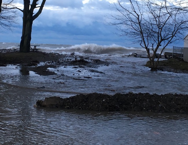
  • Potential for shoreline erosion and damage to shoreline protection works along the Lake Erie shoreline
  • Flood prone areas such as Erie Shore Drive could see flooding from wave spray
  • Creek outlets in areas such as Rose Beach Line could get blocked by sand leading to flooding


Environment Canada’s Marine Forecast has issued a Gale wind warning for Western Lake Erie. Forecasts are calling for strong sustained winds with speeds over 35 km/hr from the south (southeast through southwest) overnight tonight through Wednesday. During the late overnight period winds are forecasted to be from the southeast with wind speeds of 45 km/hr and gusts up to 70 km/hr. Through the morning, winds will shift to the southwest and remain high. Tuesday afternoon winds are forecasted to reach 60 km/hr with gusts up to 90 km/hr (possibly higher over the water). Tuesday evening, winds are expected to shift more westerly and decrease to around 35 km/hr where they are forecasted to remain throughout the day Wednesday. Waves are forecasted to reach 2-3 m in height on Tuesday.

Strong winds will be driving waves onto our Lake Erie shoreline in Chatham-Kent and Elgin County. There is a risk that wave action could damage shoreline protection works and cause shoreline erosion. In flood prone areas such as Erie Shore Drive, and some specific areas around Wheatley, there is a risk of flooding caused by waves crashing against the shoreline protection works and spraying water up onto the land. While winds are from the southeast direction, there is also a risk for the Rose Beach Line area in Chatham-Kent as recently strong winds from that direction have caused erosion in the area and caused sand to block the outlets of creeks and municipal drainage leading to backup flooding. This could also occur along other areas of the shoreline. Residents along the Lake Erie shoreline should pay attention to weather forecasts and prepare accordingly.

People should take extra caution and avoid the shoreline should conditions get rough. The waves can be strong and the shoreline slippery. There could also be hazardous debris within the waves and water which could be thrown onto the shoreline. Standing water can also present unseen hazards. Children and pets should be kept away from the water. Officials will continue to monitor the situation and update this advisory if necessary.

Contact: Jason Wintermute ([email protected]) regarding this message.

This message will be in effect until November 8th, 2018.

Share

What’s New?

  • Watershed Condition Statement – Safety Bulletin – Thames River – April 7, 2025 – 12:00 PM
  • Flood Watch – Thames River and smaller watercourses – April 6, 2025 – 1:00 PM
  • Flood Watch – Thames River and smaller watercourses – April 5, 2025 – 9:00 AM
  • Flood Watch – Thames River and smaller watercourses – April 3, 2025 – 3:00 PM
  • Watershed Condition Statement – Flood Outlook – Smaller watercourses and Thames River – April 1, 2025 – 2:00 PM

Facebook

What’s New?

  • Breakfast & BMPs – Register Today!
  • NEW! Funding for Farmers – 2025 Guide and Application Form
  • Create Something this March Break
  • Battle of Longwoods Returns to Longwoods Road Conservation Area
  • Birding at Big ‘O’

Partner Links

  • Lower Thames Valley Conservation Foundation
  • Conservation Ontario
  • Thames Heritage River; Canadian Heritage Rivers System
  • Chatham-Kent and Lambton Children’s Water Festival
  • Thames-Sydenham & Region Source Protection Area
  • Thames River Clear Water Revival

Connect with us!

Search

© 2025 · Lower Thames Valley Conservation Authority |[email protected] | Tel: 519-354-7310

  • Home
  • Privacy
  • Public Social Media Policy
  • Contact Form
Prev Next