• Home
  • About Us
    • Governance
      • About the LTVCA
      • Board of Directors
      • Board Meetings
      • Budget & Financial Statements
      • Public Consultation & Bids
      • Reports/ Plans/ Fees / MOUs
    • Get Involved
      • Employment
      • Volunteers
      • FAQ’s
      • What’s New?
  • Visit
    • Get Outside
      • Conservation Areas
      • Camping
      • Parking Passes
      • Healthy Hikes
    • Things to Do
      • Events
      • Ska-Nah-Doht Village & Museum
  • Conservation
    • Water Management
      • Flood Forecasting & Warning
      • LTVCA’s Flood Control Program
      • Water Control Structures
      • The History of Flooding
      • Flood Notices
      • Flood Notice Types
      • Water Levels
    • Conservation Services
      • Tree Planting
      • Grants for Landowners
      • Feature Partnership & Restoration Projects
      • Phosphorus Education
      • Funding for Farmers
      • Species at Risk
      • Invasive Species
      • Pollinator Habitats
      • Livestock Health
      • LIVING LAB – ONTARIO
  • Learning
    • Education Programs
      • School & Community Groups
      • On-the-Road Programs
      • Asynchronous Opportunities
      • Habitat Fact Resources
  • Planning & Regulations
    • Planning and Regs
      • Plan Input & Review
      • Regulations
      • Enforcement & Compliance
      • Regulated Areas Map
  • Contact Us
    • Get In Touch
      • Contact Form
      • Enforcement & Compliance
      • Staff Directory

Call us 519-354-7310

[email protected]
Lower Thames Valley Conservation AuthorityLower Thames Valley Conservation Authority
  • Home
  • About Us
    • Governance
      • About the LTVCA
      • Board of Directors
      • Board Meetings
      • Budget & Financial Statements
      • Public Consultation & Bids
      • Reports/ Plans/ Fees / MOUs
    • Get Involved
      • Employment
      • Volunteers
      • FAQ’s
      • What’s New?
  • Visit
    • Get Outside
      • Conservation Areas
      • Camping
      • Parking Passes
      • Healthy Hikes
    • Things to Do
      • Events
      • Ska-Nah-Doht Village & Museum
  • Conservation
    • Water Management
      • Flood Forecasting & Warning
      • LTVCA’s Flood Control Program
      • Water Control Structures
      • The History of Flooding
      • Flood Notices
      • Flood Notice Types
      • Water Levels
    • Conservation Services
      • Tree Planting
      • Grants for Landowners
      • Feature Partnership & Restoration Projects
      • Phosphorus Education
      • Funding for Farmers
      • Species at Risk
      • Invasive Species
      • Pollinator Habitats
      • Livestock Health
      • LIVING LAB – ONTARIO
  • Learning
    • Education Programs
      • School & Community Groups
      • On-the-Road Programs
      • Asynchronous Opportunities
      • Habitat Fact Resources
  • Planning & Regulations
    • Planning and Regs
      • Plan Input & Review
      • Regulations
      • Enforcement & Compliance
      • Regulated Areas Map
  • Contact Us
    • Get In Touch
      • Contact Form
      • Enforcement & Compliance
      • Staff Directory

LTVCA – Flood Watch – Local Watercourses (Updated) – July 29, 2019

Home » LTVCA – Flood Watch – Local Watercourses (Updated) – July 29, 2019
LTVCA – Flood Watch – Local Watercourses (Updated) – July 29, 2019

LTVCA – Flood Watch – Local Watercourses (Updated) – July 29, 2019

July 29, 2019

Highlights:

• Thunderstorms passing through the region yesterday dropped significant volumes of rain in some areas.
• There are more thunderstorms in the forecast for this evening and overnight that could cause additional flooding both on local watercourses and in shoreline areas.
• The McGregor Creek and Rondeau Bay watersheds would be most susceptible considering the volume of rain they received last night.

A series of thunderstorms passed through the region yesterday dropping significant volumes of rain. Much of the watershed received over 25 mm of rain and radar suggests several areas received over 100 mm of rain. Forecasts for this evening and overnight suggest there could be more thunderstorms approaching. Strong sustained southwest winds of around 30 km/hour are forecasted to accompany the thunderstorms and wind gusts would be expected to be much greater. Given the significant amount of rain already received in some areas, if the thunderstorms produce more rain, there could be further flooding.

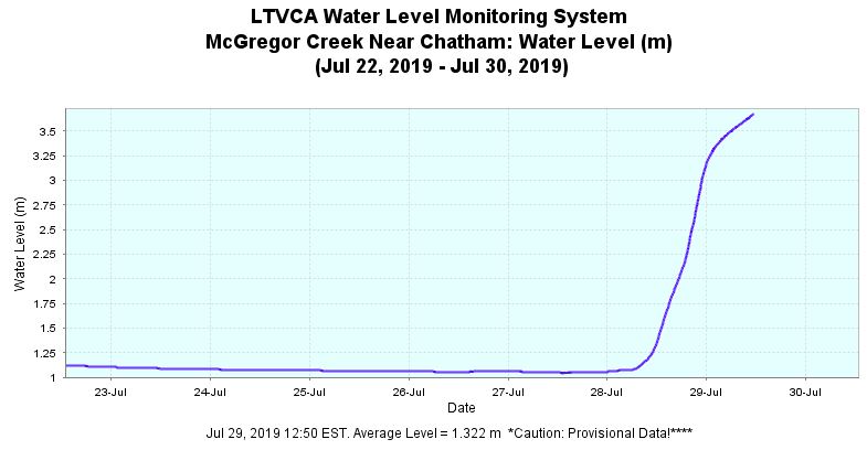
The downstream reaches of McGregor Creek are still rising slowly and have yet to peak. The LTVCA has not yet begun operating the McGregor Creek Diversion Channel. However, should thunderstorms this evening and overnight drop substantially more rain, the LTVCA may still need to operate the Diversion. The McGregor Creek and Rondeau Bay watersheds are still saturated from yesterday’s rains and any additional rain would lead to further ponding and localized flooding in low lying areas. People living and working near areas that typically see flooding during heavy rains should pay close attention to local conditions. Water levels on these local watercourses should be expected to remain into Tuesday, especially should more thunderstorms appear.

The strong southwest winds predicted to accompany this thunderstorm system could produce water level changes and waves that cause shoreline issues. The southwest winds could create flooding and erosion issues along the entire Lake Erie shoreline, especially Erie Shore Drive. Of course, other shoreline areas are also susceptible, including the high bluff areas. Heavy rains associated with thundershowers could also cause flooding in low lying shoreline areas. Due to the high lake levels, the groundwater table is high and storm water sewer systems and local watercourses are full with lake water. As a result, rainwater is not draining properly from these areas. Any water from upstream making its way downstream on these watercourses into these shoreline areas could cause additional flooding. Given the rainfall that occurred yesterday, the Rondeau Bay watershed, including Shrewsbury would be particularly at risk for this. Shoreline residents need to pay attention as local conditions change and prepare accordingly.

People should take extra caution and avoid the shoreline and any waterways with elevated water levels. The waves on the lakes can be strong, and the shoreline and the banks of waterways can be slippery and unstable. There could also be hazardous debris within the waves and water which could be thrown onto the shoreline. Standing water can also present unseen hazards. Children and animals should be kept away from the water.

Officials will continue to monitor the situation and update this advisory if necessary.

This message will be in effect until August 1, 2019.

Message Contact: LTVCA Administration Office (519-354-7310) or Jason Homewood ([email protected]).

Share

What’s New?

  • Watershed Condition Statement – Safety Bulletin – Thames River – April 7, 2025 – 12:00 PM
  • Flood Watch – Thames River and smaller watercourses – April 6, 2025 – 1:00 PM
  • Flood Watch – Thames River and smaller watercourses – April 5, 2025 – 9:00 AM
  • Flood Watch – Thames River and smaller watercourses – April 3, 2025 – 3:00 PM
  • Watershed Condition Statement – Flood Outlook – Smaller watercourses and Thames River – April 1, 2025 – 2:00 PM

Facebook

What’s New?

  • Breakfast & BMPs – Register Today!
  • NEW! Funding for Farmers – 2025 Guide and Application Form
  • Create Something this March Break
  • Battle of Longwoods Returns to Longwoods Road Conservation Area
  • Birding at Big ‘O’

Partner Links

  • Lower Thames Valley Conservation Foundation
  • Conservation Ontario
  • Thames Heritage River; Canadian Heritage Rivers System
  • Chatham-Kent and Lambton Children’s Water Festival
  • Thames-Sydenham & Region Source Protection Area
  • Thames River Clear Water Revival

Connect with us!

Search

© 2025 · Lower Thames Valley Conservation Authority |[email protected] | Tel: 519-354-7310

  • Home
  • Privacy
  • Public Social Media Policy
  • Contact Form
Prev Next