• Home
  • About Us
    • Governance
      • About the LTVCA
      • Board of Directors
      • Board Meetings
      • Budget & Financial Statements
      • Public Consultation & Bids
      • Reports/ Plans/ Fees / MOUs
    • Get Involved
      • Employment
      • Volunteers
      • FAQ’s
      • What’s New?
  • Visit
    • Get Outside
      • Conservation Areas
      • Camping
      • Parking Passes
      • Healthy Hikes
    • Things to Do
      • Events
      • Ska-Nah-Doht Village & Museum
  • Conservation
    • Water Management
      • Flood Forecasting & Warning
      • LTVCA’s Flood Control Program
      • Water Control Structures
      • The History of Flooding
      • Flood Notices
      • Flood Notice Types
      • Water Levels
    • Conservation Services
      • Tree Planting
      • Grants for Landowners
      • Feature Partnership & Restoration Projects
      • Phosphorus Education
      • Funding for Farmers
      • Species at Risk
      • Invasive Species
      • Pollinator Habitats
      • Livestock Health
      • LIVING LAB – ONTARIO
  • Learning
    • Education Programs
      • School & Community Groups
      • On-the-Road Programs
      • Asynchronous Opportunities
      • Habitat Fact Resources
  • Planning & Regulations
    • Planning and Regs
      • Plan Input & Review
      • Regulations
      • Enforcement & Compliance
      • Regulated Areas Map
  • Contact Us
    • Get In Touch
      • Contact Form
      • Enforcement & Compliance
      • Staff Directory

Call us 519-354-7310

[email protected]
Lower Thames Valley Conservation AuthorityLower Thames Valley Conservation Authority
  • Home
  • About Us
    • Governance
      • About the LTVCA
      • Board of Directors
      • Board Meetings
      • Budget & Financial Statements
      • Public Consultation & Bids
      • Reports/ Plans/ Fees / MOUs
    • Get Involved
      • Employment
      • Volunteers
      • FAQ’s
      • What’s New?
  • Visit
    • Get Outside
      • Conservation Areas
      • Camping
      • Parking Passes
      • Healthy Hikes
    • Things to Do
      • Events
      • Ska-Nah-Doht Village & Museum
  • Conservation
    • Water Management
      • Flood Forecasting & Warning
      • LTVCA’s Flood Control Program
      • Water Control Structures
      • The History of Flooding
      • Flood Notices
      • Flood Notice Types
      • Water Levels
    • Conservation Services
      • Tree Planting
      • Grants for Landowners
      • Feature Partnership & Restoration Projects
      • Phosphorus Education
      • Funding for Farmers
      • Species at Risk
      • Invasive Species
      • Pollinator Habitats
      • Livestock Health
      • LIVING LAB – ONTARIO
  • Learning
    • Education Programs
      • School & Community Groups
      • On-the-Road Programs
      • Asynchronous Opportunities
      • Habitat Fact Resources
  • Planning & Regulations
    • Planning and Regs
      • Plan Input & Review
      • Regulations
      • Enforcement & Compliance
      • Regulated Areas Map
  • Contact Us
    • Get In Touch
      • Contact Form
      • Enforcement & Compliance
      • Staff Directory

Flood Watch – May 5th, 2017 – 11:15 a.m.

Home » Flood Watch – May 5th, 2017 – 11:15 a.m.
Flood Watch – May 5th, 2017 – 11:15 a.m.

Flood Watch – May 5th, 2017 – 11:15 a.m.

May 5, 2017

The Lower Thames watershed has received between 30 and 40 mm of rainfall yesterday and this morning. The Upper Thames watershed received slightly less. Weather forecasts are calling for an additional 15 to 25 mm of rain today and another 5-10 on Saturday. The Environment Canada Rainfall Warning is still in effect.

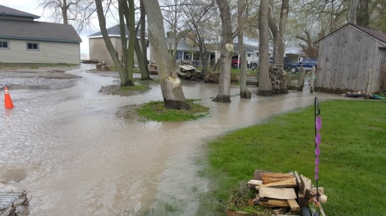
Local watercourses are running high with some reaching bank full conditions or even spilling their banks. The Lower Thames Valley Conservation Authority began operating the Indian-McGregor Creek Diversion Channel last night to protect the south end of the City of Chatham from flooding.

The Thames River itself was already running high from the rainfall on Sunday/Monday and is now on the rise again due to the recent rainfall. The river will rise and flood the river flats from Delaware to Chatham, starting this evening in the upstream areas and working its way downstream over the weekend. The sidewalk along the river in downtown Chatham is already under water in some places. If the higher predicted rainfall amounts appear, the Lower Thames Valley Conservation Authority may have to operate the 6th Street Backwater Dam and Pumping Station in downtown Chatham to prevent the Thames River from flooding back up McGregor Creek. The Thames River should be expected remain high into the middle of next week.

Lake St. Clair water levels are currently 10-15 cm under their record high levels. Strong winds out of the north are predicted throughout the weekend with speeds reaching 40 km/hr gusting to 60 km/hr this afternoon. There is a risk that wave action could damage shoreline protection works and cause shoreline erosion along those areas of the Lake St. Clair shoreline within the jurisdiction of the LTVCA, such as the Lighthouse Cove area and the shoreline of Dover Township. There is also the possibility of localized flooding caused when waves hit shoreline protection works and spray up onto the land. Sustained winds from north have the potential to raise lake levels in the region and to aggravate the situation.

People should take extra caution and avoid the shoreline, river, ditches, and streams. The combination of slippery banks and rough or fast moving cold water can be dangerous. Standing water can also present its own unseen hazards. Children, pets and livestock should be kept away from the water.

Officials will continue to monitor the situation and update this advisory if necessary.

This message will be in effect until May 10th, 2017.

Contact: Jason Wintermute (519- 354-7310 x227, [email protected]) regarding this message.

Share

What’s New?

  • Watershed Condition Statement – Safety Bulletin – Thames River – April 7, 2025 – 12:00 PM
  • Flood Watch – Thames River and smaller watercourses – April 6, 2025 – 1:00 PM
  • Flood Watch – Thames River and smaller watercourses – April 5, 2025 – 9:00 AM
  • Flood Watch – Thames River and smaller watercourses – April 3, 2025 – 3:00 PM
  • Watershed Condition Statement – Flood Outlook – Smaller watercourses and Thames River – April 1, 2025 – 2:00 PM

Facebook

What’s New?

  • Breakfast & BMPs – Register Today!
  • NEW! Funding for Farmers – 2025 Guide and Application Form
  • Create Something this March Break
  • Battle of Longwoods Returns to Longwoods Road Conservation Area
  • Birding at Big ‘O’

Partner Links

  • Lower Thames Valley Conservation Foundation
  • Conservation Ontario
  • Thames Heritage River; Canadian Heritage Rivers System
  • Chatham-Kent and Lambton Children’s Water Festival
  • Thames-Sydenham & Region Source Protection Area
  • Thames River Clear Water Revival

Connect with us!

Search

© 2025 · Lower Thames Valley Conservation Authority |[email protected] | Tel: 519-354-7310

  • Home
  • Privacy
  • Public Social Media Policy
  • Contact Form
Prev Next