• Home
  • About Us
    • Governance
      • About the LTVCA
      • Board of Directors
      • Board Meetings
      • Budget & Financial Statements
      • Public Consultation & Bids
      • Reports/ Plans/ Fees / MOUs
    • Get Involved
      • Employment
      • Volunteers
      • FAQ’s
      • What’s New?
  • Visit
    • Get Outside
      • Conservation Areas
      • Camping
      • Parking Passes
      • Healthy Hikes
    • Things to Do
      • Events
      • Ska-Nah-Doht Village & Museum
  • Conservation
    • Water Management
      • Flood Forecasting & Warning
      • LTVCA’s Flood Control Program
      • Water Control Structures
      • The History of Flooding
      • Flood Notices
      • Flood Notice Types
      • Water Levels
    • Conservation Services
      • Tree Planting
      • Grants for Landowners
      • Feature Partnership & Restoration Projects
      • Phosphorus Education
      • Funding for Farmers
      • Species at Risk
      • Invasive Species
      • Pollinator Habitats
      • Livestock Health
      • LIVING LAB – ONTARIO
  • Learning
    • Education Programs
      • School & Community Groups
      • On-the-Road Programs
      • Asynchronous Opportunities
      • Habitat Fact Resources
  • Planning & Regulations
    • Planning and Regs
      • Plan Input & Review
      • Regulations
      • Enforcement & Compliance
      • Regulated Areas Map
  • Contact Us
    • Get In Touch
      • Contact Form
      • Enforcement & Compliance
      • Staff Directory

Call us 519-354-7310

[email protected]
Lower Thames Valley Conservation AuthorityLower Thames Valley Conservation Authority
  • Home
  • About Us
    • Governance
      • About the LTVCA
      • Board of Directors
      • Board Meetings
      • Budget & Financial Statements
      • Public Consultation & Bids
      • Reports/ Plans/ Fees / MOUs
    • Get Involved
      • Employment
      • Volunteers
      • FAQ’s
      • What’s New?
  • Visit
    • Get Outside
      • Conservation Areas
      • Camping
      • Parking Passes
      • Healthy Hikes
    • Things to Do
      • Events
      • Ska-Nah-Doht Village & Museum
  • Conservation
    • Water Management
      • Flood Forecasting & Warning
      • LTVCA’s Flood Control Program
      • Water Control Structures
      • The History of Flooding
      • Flood Notices
      • Flood Notice Types
      • Water Levels
    • Conservation Services
      • Tree Planting
      • Grants for Landowners
      • Feature Partnership & Restoration Projects
      • Phosphorus Education
      • Funding for Farmers
      • Species at Risk
      • Invasive Species
      • Pollinator Habitats
      • Livestock Health
      • LIVING LAB – ONTARIO
  • Learning
    • Education Programs
      • School & Community Groups
      • On-the-Road Programs
      • Asynchronous Opportunities
      • Habitat Fact Resources
  • Planning & Regulations
    • Planning and Regs
      • Plan Input & Review
      • Regulations
      • Enforcement & Compliance
      • Regulated Areas Map
  • Contact Us
    • Get In Touch
      • Contact Form
      • Enforcement & Compliance
      • Staff Directory

Flood Watch – Lake Erie Shoreline (various areas) – September 9, 2018 – 9:30 a.m.

Home » Flood Watch – Lake Erie Shoreline (various areas) – September 9, 2018 – 9:30 a.m.
Flood Watch – Lake Erie Shoreline (various areas) – September 9, 2018 – 9:30 a.m.

Flood Watch – Lake Erie Shoreline (various areas) – September 9, 2018 – 9:30 a.m.

September 9, 2018

Environment Canada’s Marine Forecast has issued a Gale Warning for western Lake Erie due to predicted high winds today through tomorrow morning.  Current information suggests that shoreline areas are currently experiencing sustained winds of 40 km/hr out of the east with gusts over 50 km/hr.  Winds are expected to slowly increase through the day peaking at around 55 km/hr with gust of 80 km/hr around midnight.  Winds are then expected to slowly decrease and shift to the south staying above 35 km/hr until tomorrow afternoon.  Offshore weather buoys are measuring wave heights over 2m and the marine forecasts suggests waves could reach 3m today.  Forecast are still calling for 30 mm or more of rain beginning this afternoon through Monday morning.

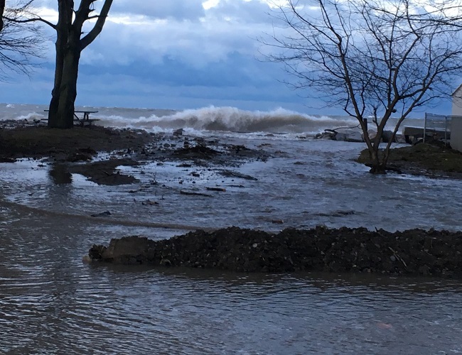
Throughout this period there is a risk that wave action could damage shoreline protection works and cause shoreline erosion.  Vulnerable areas will likely see localized flooding due to waves crashing against shoreline protection works spraying water up onto the land.  These consistent strong winds from the east will raise water levels at the western end of Lake Erie increasing the risk of shoreline flooding and erosion damage. These winds present a greater risk than usual for the interior areas of Rondeau Bay such as Erieau and Shrewsbury and for the shoreline just east of Rondeau Provincial Park.  However the wave action will still affect areas more typically impacted by wind events on Lake Erie such as Erie Shore Drive.  As the winds switch to the south overnight, the winds will be more directly driving waves onto our Lake Erie shoreline in Chatham-Kent and Elgin County.

People should take extra caution and avoid the shoreline.  The waves can be strong and the shoreline slippery.  There could also be hazardous debris within the waves and water.  Standing water can also present its own unseen hazards.  Children and pets should be kept away from the water.

Officials will continue to monitor the situation and update this advisory if necessary.
This message will be in effect until Tuesday September 11th, 2018.

Contact:  Jason Wintermute ([email protected]) or Jason Homewood ([email protected])

Share

What’s New?

  • Watershed Condition Statement – Safety Bulletin – Thames River – April 7, 2025 – 12:00 PM
  • Flood Watch – Thames River and smaller watercourses – April 6, 2025 – 1:00 PM
  • Flood Watch – Thames River and smaller watercourses – April 5, 2025 – 9:00 AM
  • Flood Watch – Thames River and smaller watercourses – April 3, 2025 – 3:00 PM
  • Watershed Condition Statement – Flood Outlook – Smaller watercourses and Thames River – April 1, 2025 – 2:00 PM

Facebook

What’s New?

  • Breakfast & BMPs – Register Today!
  • NEW! Funding for Farmers – 2025 Guide and Application Form
  • Create Something this March Break
  • Battle of Longwoods Returns to Longwoods Road Conservation Area
  • Birding at Big ‘O’

Partner Links

  • Lower Thames Valley Conservation Foundation
  • Conservation Ontario
  • Thames Heritage River; Canadian Heritage Rivers System
  • Chatham-Kent and Lambton Children’s Water Festival
  • Thames-Sydenham & Region Source Protection Area
  • Thames River Clear Water Revival

Connect with us!

Search

© 2025 · Lower Thames Valley Conservation Authority |[email protected] | Tel: 519-354-7310

  • Home
  • Privacy
  • Public Social Media Policy
  • Contact Form
Prev Next