• Home
  • About Us
    • Governance
      • About the LTVCA
      • Board of Directors
      • Board Meetings
      • Budget & Financial Statements
      • Public Consultation & Bids
      • Reports/ Plans/ Fees / MOUs
    • Get Involved
      • Employment
      • Volunteers
      • FAQ’s
      • What’s New?
  • Visit
    • Get Outside
      • Conservation Areas
      • Camping
      • Parking Passes
      • Healthy Hikes
    • Things to Do
      • Events
      • Ska-Nah-Doht Village & Museum
  • Conservation
    • Water Management
      • Flood Forecasting & Warning
      • LTVCA’s Flood Control Program
      • Water Control Structures
      • The History of Flooding
      • Flood Notices
      • Flood Notice Types
      • Water Levels
    • Conservation Services
      • Tree Planting
      • Grants for Landowners
      • Feature Partnership & Restoration Projects
      • Phosphorus Education
      • Funding for Farmers
      • Species at Risk
      • Invasive Species
      • Pollinator Habitats
      • Livestock Health
      • LIVING LAB – ONTARIO
  • Learning
    • Education Programs
      • School & Community Groups
      • On-the-Road Programs
      • Asynchronous Opportunities
      • Habitat Fact Resources
  • Planning & Regulations
    • Planning and Regs
      • Plan Input & Review
      • Regulations
      • Enforcement & Compliance
      • Regulated Areas Map
  • Contact Us
    • Get In Touch
      • Contact Form
      • Enforcement & Compliance
      • Staff Directory

Call us 519-354-7310

[email protected]
Lower Thames Valley Conservation AuthorityLower Thames Valley Conservation Authority
  • Home
  • About Us
    • Governance
      • About the LTVCA
      • Board of Directors
      • Board Meetings
      • Budget & Financial Statements
      • Public Consultation & Bids
      • Reports/ Plans/ Fees / MOUs
    • Get Involved
      • Employment
      • Volunteers
      • FAQ’s
      • What’s New?
  • Visit
    • Get Outside
      • Conservation Areas
      • Camping
      • Parking Passes
      • Healthy Hikes
    • Things to Do
      • Events
      • Ska-Nah-Doht Village & Museum
  • Conservation
    • Water Management
      • Flood Forecasting & Warning
      • LTVCA’s Flood Control Program
      • Water Control Structures
      • The History of Flooding
      • Flood Notices
      • Flood Notice Types
      • Water Levels
    • Conservation Services
      • Tree Planting
      • Grants for Landowners
      • Feature Partnership & Restoration Projects
      • Phosphorus Education
      • Funding for Farmers
      • Species at Risk
      • Invasive Species
      • Pollinator Habitats
      • Livestock Health
      • LIVING LAB – ONTARIO
  • Learning
    • Education Programs
      • School & Community Groups
      • On-the-Road Programs
      • Asynchronous Opportunities
      • Habitat Fact Resources
  • Planning & Regulations
    • Planning and Regs
      • Plan Input & Review
      • Regulations
      • Enforcement & Compliance
      • Regulated Areas Map
  • Contact Us
    • Get In Touch
      • Contact Form
      • Enforcement & Compliance
      • Staff Directory

Flood Warning – February 22nd, 2018 – 8:20 PM

Home » Flood Warning – February 22nd, 2018 – 8:20 PM
Flood Warning – February 22nd, 2018 – 8:20 PM

Flood Warning – February 22nd, 2018 – 8:20 PM

February 22, 2018

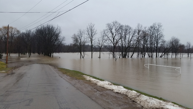
Warm temperatures, melting snow and heavy rainfall over the last week have led to flooding in the Thames River watershed.

Water levels on the Thames River in London are now dropping and the peak is moving through Middlesex and Elgin Counties. Water levels will be peaking this evening around the Currie Road / Thames Road areas. Water levels are expected to peak in the Thamesville and Chatham areas tomorrow evening through Saturday morning.

As the peak passes Thamesville, water is expected to back up local creeks into the community and cause flooding. Based on past flooding events, water levels at the center of the community can be expected to be between 0.3 m and 0.5 m deep. These depths of flooding would be somewhere between what was experienced in 2008/2009 and the 1977 flood. The time that flooding may begin is uncertain but residents should prepare for the afternoon. Please contact the Municipality of Chatham-Kent should additional support be required.

Along the Thames River in the City of Chatham, water levels are also expected to climb significantly. Water levels can be expected somewhere between those observed during the 1977 flood and the 1968 flood. Based on water levels observed this afternoon, this would be an additional rise of 1.3 to 1.6 m. This will put significant water depths over those roads previously mentioned (such as Siskind Court, the area around William and Water, Salter, the west of Pegley, and the low portion of Thames St along the river), and there may be other road closures as well. Please contact the Municipality of Chatham-Kent should additional support be required.

While the smaller local watercourse that drain into the Thames River had started to decline, with high flows of the river, water is now backing up these watercourse and may cause flooding in adjacent areas.

High water levels can be expected throughout the Lower Thames into early next week.

Residents with properties that back onto watercourses and the river should secure their properties and remove any items that could be damaged by flooding or get loose and become floating debris. Attempts should also be made to ensure that catch basins and other drainage works are free of debris and can function properly.

People should take extra caution and avoid the river, ditches, and streams. The combination of slippery banks, floating debris, and fast moving cold water can be dangerous. Standing water can also present its own unseen hazards. Children, pets and livestock should be kept away from the water.

Officials will continue to monitor the situation and update this advisory if necessary.

This message will be in effect until February 24th, 2018.

Contact: Jason Wintermute ([email protected], 519-354-7310 x227) regarding this message.

Share

What’s New?

  • Watershed Condition Statement – Safety Bulletin – Thames River – April 7, 2025 – 12:00 PM
  • Flood Watch – Thames River and smaller watercourses – April 6, 2025 – 1:00 PM
  • Flood Watch – Thames River and smaller watercourses – April 5, 2025 – 9:00 AM
  • Flood Watch – Thames River and smaller watercourses – April 3, 2025 – 3:00 PM
  • Watershed Condition Statement – Flood Outlook – Smaller watercourses and Thames River – April 1, 2025 – 2:00 PM

Facebook

What’s New?

  • Breakfast & BMPs – Register Today!
  • NEW! Funding for Farmers – 2025 Guide and Application Form
  • Create Something this March Break
  • Battle of Longwoods Returns to Longwoods Road Conservation Area
  • Birding at Big ‘O’

Partner Links

  • Lower Thames Valley Conservation Foundation
  • Conservation Ontario
  • Thames Heritage River; Canadian Heritage Rivers System
  • Chatham-Kent and Lambton Children’s Water Festival
  • Thames-Sydenham & Region Source Protection Area
  • Thames River Clear Water Revival

Connect with us!

Search

© 2025 · Lower Thames Valley Conservation Authority |[email protected] | Tel: 519-354-7310

  • Home
  • Privacy
  • Public Social Media Policy
  • Contact Form
Prev Next