• Home
  • About Us
    • Governance
      • About the LTVCA
      • Board of Directors
      • Board Meetings
      • Budget & Financial Statements
      • Public Consultation & Bids
      • Reports/ Plans/ Fees / MOUs
    • Get Involved
      • Employment
      • Volunteers
      • FAQ’s
      • What’s New?
  • Visit
    • Get Outside
      • Conservation Areas
      • Camping
      • Parking Passes
      • Healthy Hikes
    • Things to Do
      • Events
      • Ska-Nah-Doht Village & Museum
  • Conservation
    • Water Management
      • Flood Forecasting & Warning
      • LTVCA’s Flood Control Program
      • Water Control Structures
      • The History of Flooding
      • Flood Notices
      • Flood Notice Types
      • Water Levels
    • Conservation Services
      • Tree Planting
      • Grants for Landowners
      • Feature Partnership & Restoration Projects
      • Phosphorus Education
      • Funding for Farmers
      • Species at Risk
      • Invasive Species
      • Pollinator Habitats
      • Livestock Health
      • LIVING LAB – ONTARIO
  • Learning
    • Education Programs
      • School & Community Groups
      • On-the-Road Programs
      • Asynchronous Opportunities
      • Habitat Fact Resources
  • Planning & Regulations
    • Planning and Regs
      • Plan Input & Review
      • Regulations
      • Enforcement & Compliance
      • Regulated Areas Map
  • Contact Us
    • Get In Touch
      • Contact Form
      • Enforcement & Compliance
      • Staff Directory

Call us 519-354-7310

[email protected]
Lower Thames Valley Conservation AuthorityLower Thames Valley Conservation Authority
  • Home
  • About Us
    • Governance
      • About the LTVCA
      • Board of Directors
      • Board Meetings
      • Budget & Financial Statements
      • Public Consultation & Bids
      • Reports/ Plans/ Fees / MOUs
    • Get Involved
      • Employment
      • Volunteers
      • FAQ’s
      • What’s New?
  • Visit
    • Get Outside
      • Conservation Areas
      • Camping
      • Parking Passes
      • Healthy Hikes
    • Things to Do
      • Events
      • Ska-Nah-Doht Village & Museum
  • Conservation
    • Water Management
      • Flood Forecasting & Warning
      • LTVCA’s Flood Control Program
      • Water Control Structures
      • The History of Flooding
      • Flood Notices
      • Flood Notice Types
      • Water Levels
    • Conservation Services
      • Tree Planting
      • Grants for Landowners
      • Feature Partnership & Restoration Projects
      • Phosphorus Education
      • Funding for Farmers
      • Species at Risk
      • Invasive Species
      • Pollinator Habitats
      • Livestock Health
      • LIVING LAB – ONTARIO
  • Learning
    • Education Programs
      • School & Community Groups
      • On-the-Road Programs
      • Asynchronous Opportunities
      • Habitat Fact Resources
  • Planning & Regulations
    • Planning and Regs
      • Plan Input & Review
      • Regulations
      • Enforcement & Compliance
      • Regulated Areas Map
  • Contact Us
    • Get In Touch
      • Contact Form
      • Enforcement & Compliance
      • Staff Directory

Flood Outlook – Lake Erie Shoreline – October 02, 2019

Home » Flood Outlook – Lake Erie Shoreline – October 02, 2019
Flood Outlook – Lake Erie Shoreline – October 02, 2019

Flood Outlook – Lake Erie Shoreline – October 02, 2019

October 2, 2019

Highlights:
• Strong Wind Warning has been issued for Lake Erie due to strong northeast winds this evening into tomorrow morning.
• Risk of shoreline damage, erosion and flooding along the Lake Erie shore, including the high bluff areas.

A Strong Wind Warning has been issued by Environment Canada due to strong northeast winds predicted for this evening, lasting overnight and into tomorrow morning. Wind speeds are forecasted to climb above 30 km/hr during the evening period and could reach speeds of 40 km/hr overnight with gusts up to 60 km/hr. Tomorrow morning (Thursday), winds are expected to drop and switch through the southeast and finally to the northwest late in the day. Forecasts suggest wave heights on Lake Erie could reach up to 2 m in height overnight. In addition to the winds, forecasts also suggest there could be 15 to 30 mm of rain during this period.

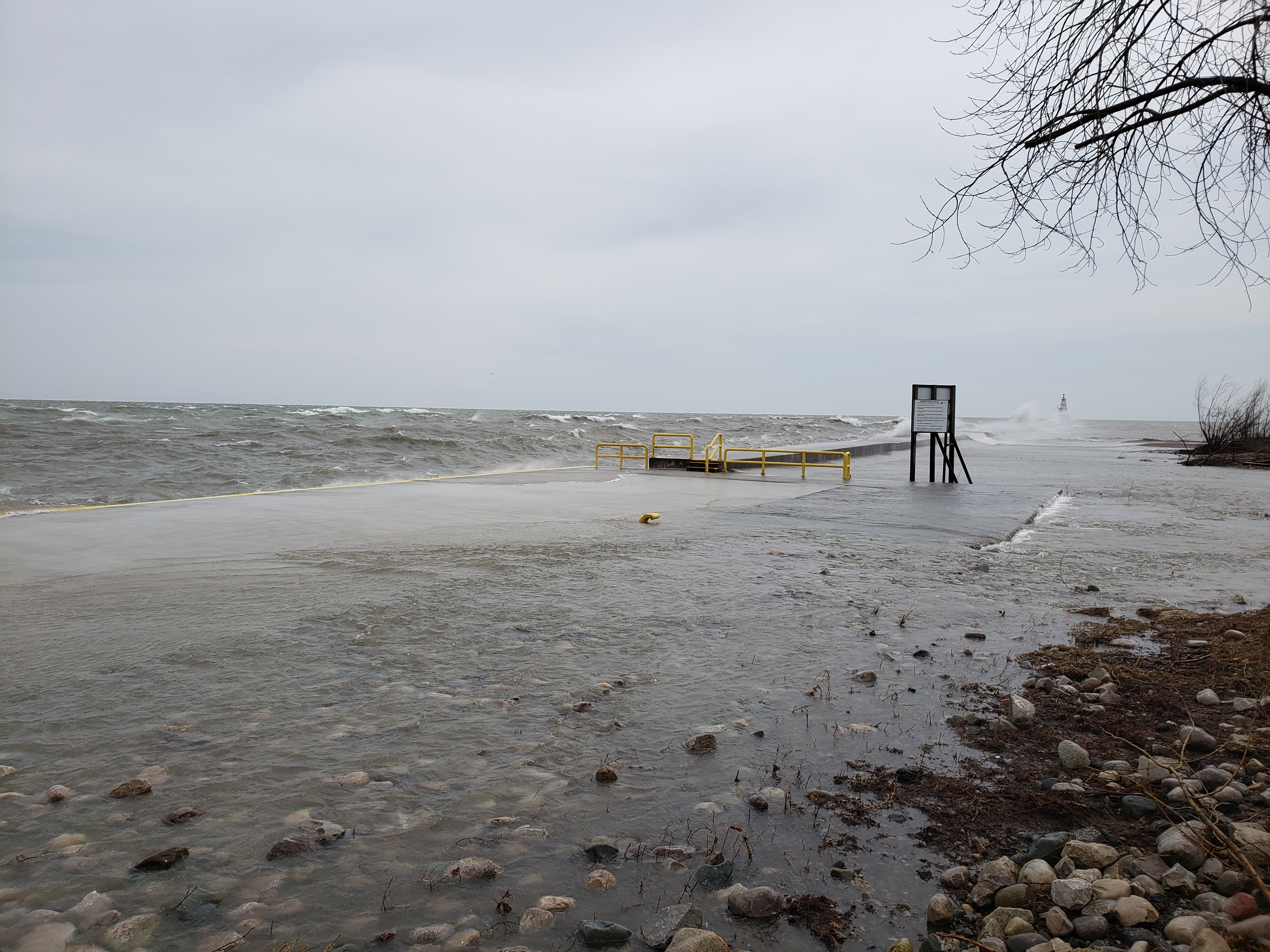
Strong winds will be driving waves onto the Lake Erie shoreline in Chatham-Kent and Elgin County throughout the evening and into tomorrow morning (Thursday). There is a risk that wave action could damage shoreline protection works and cause erosion, all along the Lake Erie shoreline, including along the high bluff areas. Low lying areas could also experience flooding. The area most likely to be impacted is the Rose Beach Line area as it will be exposed to direct wind and wave action for most of this period. The Erie Shore Drive area will be mostly sheltered during this wind event, however, there some risk that the area could be impacted should the winds not drop before switching to the southeast as predicted. The rains in the forecast could aggravate the situation. Due to the high lake levels, rainwater is not draining properly from low lying shoreline areas. Residents should pay attention to local conditions and be prepared.

People should take extra caution and avoid the shoreline should conditions get rough. The waves can be strong and the shoreline slippery. There could also be hazardous debris within the waves and water which could be thrown onto the shore. Standing water can also present unseen hazards. Children and animals should be kept away from the water.

Officials will continue to monitor the situation and update this advisory if necessary.

This message will be in effect until October 4, 2019.

Contact: Jason Wintermute (519-354-7310, [email protected]) regarding this message.

Share

What’s New?

  • Watershed Condition Statement – Safety Bulletin – Thames River – April 7, 2025 – 12:00 PM
  • Flood Watch – Thames River and smaller watercourses – April 6, 2025 – 1:00 PM
  • Flood Watch – Thames River and smaller watercourses – April 5, 2025 – 9:00 AM
  • Flood Watch – Thames River and smaller watercourses – April 3, 2025 – 3:00 PM
  • Watershed Condition Statement – Flood Outlook – Smaller watercourses and Thames River – April 1, 2025 – 2:00 PM

Facebook

What’s New?

  • Breakfast & BMPs – Register Today!
  • NEW! Funding for Farmers – 2025 Guide and Application Form
  • Create Something this March Break
  • Battle of Longwoods Returns to Longwoods Road Conservation Area
  • Birding at Big ‘O’

Partner Links

  • Lower Thames Valley Conservation Foundation
  • Conservation Ontario
  • Thames Heritage River; Canadian Heritage Rivers System
  • Chatham-Kent and Lambton Children’s Water Festival
  • Thames-Sydenham & Region Source Protection Area
  • Thames River Clear Water Revival

Connect with us!

Search

© 2025 · Lower Thames Valley Conservation Authority |[email protected] | Tel: 519-354-7310

  • Home
  • Privacy
  • Public Social Media Policy
  • Contact Form
Prev Next