• About Us
    • Vision / Mission Statement
    • About the LTVCA
    • Budget and Financial Statements
    • Board Meeting Packages and Minutes
    • Employment
    • Public Events have been cancelled due to COVID-19 Pandemic
    • FAQ’s
    • Volunteers
    • Fees & Publications
    • What’s New?
    • Public Social Media Policy
  • Planning & Regs
    • Plan Input and Review
    • Regulations
  • Water Management
    • Flood Forecasting and Warning
    • LTVCA’s Flood Control Program
    • Water Control Structures
    • The History of Flooding
    • Flood Notices
    • Flood Notice Types
    • Water Levels
  • Education Programs
    • Education Field Trip Programs
    • Non-School Group Programs
  • Conservation Areas
    • 2021 Parking Pass
    • Conservation Area Day Use & Camping Fees
    • Camping
    • Longwoods Road Conservation Area / Ska-Nah-Doht Village & Museum
      • Trail Features and Challenges
    • Big Bend Conservation Area
    • C.M. Wilson Conservation Area
    • E.M. Warwick Conservation Area
    • All Conservation Areas
  • Conservation Services
    • Tree Planting
    • Grants for Landowners
    • Feature Partnerships & Restoration Projects
    • Soil Health
    • Pollinator Habitats
    • Species at Risk
    • Invasive Species
    • McGregor and Jeannettes Creek Phosphorus Reduction Program
  • Foundation
    • About the LTVC Foundation
    • Carey Carolinian Arboretum and Trail
    • Lower Thames Valley Conservation Foundation Bursary
    • Save the Cabins
    • Memorial Forest Program
    • Fund-Raiser
    • Donate to Conservation
    • Volunteer Directors and Members
    • Ontario Trillium Foundation Capital Grant for Wheelchair Accessible Boardwalk Replacement at Longwoods Road CA
    • Trillium ‘Seed’ Grant – Longwoods Feasibility Study 2018-2019
    • Conservation Foundation Privacy Policy
  • Camping
  • Contact Us
  • 2021 LTVCA Parking Passes
21
Mar

Watershed Conditions – Safety Bulletin – March 21, 2015 – 10:00 A.M.

Watershed Conditions – Safety Bulletin – March 21, 2015 – 10:00 A.M.

Watershed Conditions – Safety Bulletin

Date: 10:00 A.M., Saturday, March 21, 2015

Issued to: Municipal Flood Coordinators of Municipalities, Media

Issued by: Lower Thames Valley Conservation Authority

Warming temperatures over the last two weeks caused most of the snowpack in the lower Thames watershed to melt and run off into the region’s watercourses.  Some of the region’s smaller watercourses had reached bank full conditions or even topped their banks.  Water levels on these smaller watercourses have now dropped and areas of localized flooding are drying out.

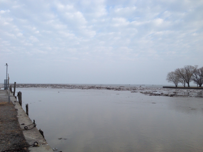
Water levels throughout the lower Thames River are also now dropping.  Yesterday evening the Thames River opened up all the way to the mouth at Lake St. Clair and overnight most of the remaining ice on the river pushed out into the lake. The risk of ice jam related flooding has passed for this year.

While this events winds down, people should take extra caution and avoid the river, lakes, ditches, streams, and ponds.  The combination of slippery banks, moving/melting ice and cold water is particularly dangerous.  Parents should pay special attention to keep their children away from the water.

The Lower Thames Valley Conservation Authority will continue to monitor conditions and will issue additional messages as required.

Contact:  Jason Wintermute (519-354-7310 x227 or this email address) regarding this message.

An update to this message is not anticipated.

0
SHARES
ShareTweet

Font Size

Zoom in Regular Zoom out

Conservation Services

  • Tree Planting
  • Grants for Landowners
  • Feature Partnerships & Restoration Projects
  • Soil Health
  • Species at Risk
  • Invasive Species
  • Pollinator Habitats
  • McGregor and Jeannettes Creek Phosphorus Reduction Program

LTVCA Program Forms

  • Agricultural Improvement Fund Application Form
  • Tree Species Price List
  • MJCPRP Application Form
  • MJCPRP Claim Form
  • MJCPRP Pamphlet

Recent Posts

  • Shoreline Condition Statement – Flood Outlook – Standing Message – Lake Erie & Lake St. Clair – High Static Water Level – April 2021
  • Offices Closed Good Friday, Easter Monday
  • Shoreline Condition Statement – Flood Outlook – Lake Erie Shoreline, Erie Shore Dr. – March 30, 2021 – 10:00 AM
  • Shoreline Condition Statement – Flood Outlook – Lake Erie & Lake St. Clair Shoreline, Erie Shore Dr., Lighthouse Cove – March 28, 2021 – 9:30 AM

Upcoming Events

  • No events

Partner Links

  • Conservation Ontario
  • Thames-Sydenham & Region Source Protection Area
  • Thames River Clear Water Revival

Search


Chatham-Kent and Lambton Children's Water Festival


Canadian Heritage Rivers


A member of
Conservation Ontario

Copyright 2020 · Lower Thames Valley Conservation Authority
  • /Home
  • /Site Map
  • /Contact Us