• About Us
    • Vision / Mission Statement
    • About the LTVCA
    • Budget and Financial Statements
    • Board Meeting Packages and Minutes
    • Employment
    • Public Events have been cancelled due to COVID-19 Pandemic
    • FAQ’s
    • Volunteers
    • Fees & Publications
    • What’s New?
    • Public Social Media Policy
  • Planning & Regs
    • Plan Input and Review
    • Regulations
  • Water Management
    • Flood Forecasting and Warning
    • LTVCA’s Flood Control Program
    • Water Control Structures
    • The History of Flooding
    • Flood Notices
    • Flood Notice Types
    • Water Levels
  • Education Programs
    • Education Field Trip Programs
    • Non-School Group Programs
  • Conservation Areas
    • 2021 Parking Pass
    • Conservation Area Day Use & Camping Fees
    • Camping
    • Longwoods Road Conservation Area / Ska-Nah-Doht Village & Museum
      • Trail Features and Challenges
    • Big Bend Conservation Area
    • C.M. Wilson Conservation Area
    • E.M. Warwick Conservation Area
    • All Conservation Areas
  • Conservation Services
    • Tree Planting
    • Grants for Landowners
    • Feature Partnerships & Restoration Projects
    • Soil Health
    • Pollinator Habitats
    • Species at Risk
    • Invasive Species
    • McGregor and Jeannettes Creek Phosphorus Reduction Program
  • Foundation
    • About the LTVC Foundation
    • Carey Carolinian Arboretum and Trail
    • Lower Thames Valley Conservation Foundation Bursary
    • Save the Cabins
    • Memorial Forest Program
    • Fund-Raiser
    • Donate to Conservation
    • Volunteer Directors and Members
    • Ontario Trillium Foundation Capital Grant for Wheelchair Accessible Boardwalk Replacement at Longwoods Road CA
    • Trillium ‘Seed’ Grant – Longwoods Feasibility Study 2018-2019
    • Conservation Foundation Privacy Policy
  • Camping
  • Contact Us
  • 2021 LTVCA Parking Passes
14
May

Watershed Conditions – Flood Outlook – May 14, 2018 – 12:00 PM

Watershed Conditions – Flood Outlook – May 14, 2018 – 12:00 PM

Environment Canada has issued a Special Weather Statement for the Chatham-Kent and Essex County regions due to significant amounts of additional rainfall in the forecast.  From last Friday afternoon through Sunday morning, the western portion of the Lower Thames watershed experienced heavy rain and storms which dropped between 50 and 100 mm of rainfall.  A series of showers and thunderstorms are passing through the region late this morning and this afternoon that could drop an additional 25 mm of rain.  Starting late this evening another round of showers and thunderstorms is expected that could drop an additional 25-35 mm through tomorrow afternoon.

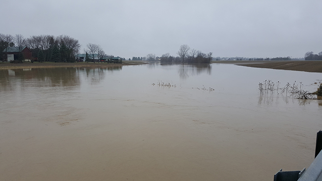
In the west of the watershed, the ground is still quite saturated due to the heavy rain over the weekend any can’t take much additional rainfall.  Should the forecasted rainfall amounts appear, there will likely to be issues of localized flooding just due to the amount of rainfall.

Water levels on the region’s smaller local watercourses are now dropping from the weekend’s rain but this additional forecasted rainfall would cause them to rise up again.  Those areas that saw high water levels or overbank flooding over the weekend could see that occur again.  In Chatham-Kent, the LTVCA expects the McGregor Creek Diversion Channel to be operating for another few days because of the rainfall.

Water levels on the Thames River are not expected to come up much due to the forecasted rains.  The Upper watershed received only a small amount of rain over the weekend and isn’t contributing significant flows to the river.

People should take extra caution and avoid the river, ditches, and streams.  The combination of slippery banks and fast moving water can be dangerous.  Standing water can also present its own unseen hazards.  Children and pets should be kept away from the water.

Officials will continue to monitor the situation and update this advisory if necessary.

This message will be in effect until May 16th, 2018.

Contact:  Jason Wintermute (jason.wintermute@ltvca.ca,), 519-354-7310 x227) regarding this message.

0
SHARES
ShareTweet

Font Size

Zoom in Regular Zoom out

Water Management

  • Flood Forecasting and Warning
  • LTVCA’s Flood Control Program
  • Water Control Structures
  • The History of Flooding
  • Flood Notices
  • Flood Notice Types
  • Water Levels
  • Harmful Algae Blooms

Flood Notice Archives

Downloads

  • Fee Schedule – Conservation Services
  • Personal Flood Emergency Plans

Recent Posts

  • Breaking Ground – 16 acres of Land Restoration is underway
  • Flood Warning – Erie Shore Drive – January 13, 2021 – 10:15 AM
  • Flood Watch – Lake Erie shoreline, Erie Shore Dr. – January 12, 2021 – 12:30 PM
  • Shoreline Condition Statement – Flood Outlook – Lake Erie Shoreline, Erie Shore Dr. – January 11, 2021 – 10:30 AM

Upcoming Events

  • No events

Partner Links

  • Conservation Ontario
  • Thames-Sydenham & Region Source Protection Area
  • Thames River Clear Water Revival

Search


Chatham-Kent and Lambton Children's Water Festival


Canadian Heritage Rivers


A member of
Conservation Ontario

Copyright 2020 · Lower Thames Valley Conservation Authority
  • /Home
  • /Site Map
  • /Contact Us