• About Us
    • Vision / Mission Statement
    • About the LTVCA
    • Budget and Financial Statements
    • Board Meeting Packages and Minutes
    • Employment
    • Public Events have been cancelled due to COVID-19 Pandemic
    • FAQ’s
    • Volunteers
    • Fees & Publications
    • What’s New?
    • Public Social Media Policy
  • Planning & Regs
    • Plan Input and Review
    • Regulations
  • Water Management
    • Flood Forecasting and Warning
    • LTVCA’s Flood Control Program
    • Water Control Structures
    • The History of Flooding
    • Flood Notices
    • Flood Notice Types
    • Water Levels
  • Education Programs
    • Education Field Trip Programs
    • Non-School Group Programs
  • Conservation Areas
    • 2021 Parking Pass
    • Conservation Area Day Use & Camping Fees
    • Camping
    • Longwoods Road Conservation Area / Ska-Nah-Doht Village & Museum
      • Trail Features and Challenges
    • Big Bend Conservation Area
    • C.M. Wilson Conservation Area
    • E.M. Warwick Conservation Area
    • All Conservation Areas
  • Conservation Services
    • Tree Planting
    • Grants for Landowners
    • Feature Partnerships & Restoration Projects
    • Soil Health
    • Pollinator Habitats
    • Species at Risk
    • Invasive Species
    • McGregor and Jeannettes Creek Phosphorus Reduction Program
  • Foundation
    • About the LTVC Foundation
    • Carey Carolinian Arboretum and Trail
    • Lower Thames Valley Conservation Foundation Bursary
    • Save the Cabins
    • Memorial Forest Program
    • Fund-Raiser
    • Donate to Conservation
    • Volunteer Directors and Members
    • Ontario Trillium Foundation Capital Grant for Wheelchair Accessible Boardwalk Replacement at Longwoods Road CA
    • Trillium ‘Seed’ Grant – Longwoods Feasibility Study 2018-2019
    • Conservation Foundation Privacy Policy
  • Camping
  • Contact Us
  • 2021 LTVCA Parking Passes
4
Aug

Watershed Conditions – Flood Outlook – Lake Erie Shoreline – August 4th, 2017 – 10:30 a.m.

Watershed Conditions – Flood Outlook – Lake Erie Shoreline – August 4th, 2017 – 10:30 a.m.

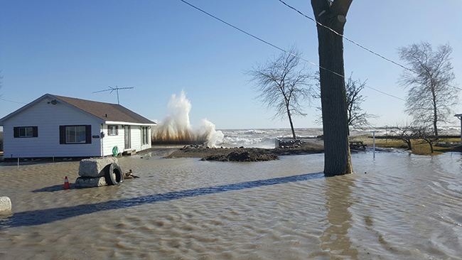
Weather forecasts are calling for strong southwesterly winds on Lake Erie late this afternoon and this evening. Environment Canada currently has a Strong Wind Warning in effect for western Lake Erie. Forecasts are calling for sustained winds of 40 to 45 km/hr late this afternoon, with gusts predicted between 65 and 80 km/hr depending on thunderstorm activity. Environment Canada’s Marine Forecasts are predicting wave heights in western Lake Erie to reach 2 m in height.

Southwesterly winds will be driving the waves onto our Lake Erie shoreline in Chatham-Kent and Elgin County. There is a risk that wave action could damage shoreline protection works and cause shoreline erosion. There could also be localized flooding due to waves crashing against the shoreline protection spraying water up onto the land. Residents in vulnerable areas along the Lake Erie shoreline should be prepared. The predicted wind speeds and wave heights are similar to, or slightly greater than, those that caused flooding and shoreline damage earlier this year along Erie Shore Drive in Chatham-Kent. Residents should pay close attention to the weather.

People should take extra caution and avoid the shoreline should conditions get rough. The waves can be strong and the shoreline slippery. There could also be hazardous debris within the waves and water. Standing water can also present its own unseen hazards. Children, pets and livestock should be kept away from the water.

Officials will continue to monitor the situation and update this advisory if necessary.
This message will be in effect until August 5th, 2017.

Contact: Jason Wintermute (519- 354-7310 x227) regarding this message.


0
SHARES
ShareTweet

Font Size

Zoom in Regular Zoom out

Water Management

  • Flood Forecasting and Warning
  • LTVCA’s Flood Control Program
  • Water Control Structures
  • The History of Flooding
  • Flood Notices
  • Flood Notice Types
  • Water Levels
  • Harmful Algae Blooms

Flood Notice Archives

Downloads

  • Fee Schedule – Conservation Services
  • Personal Flood Emergency Plans

Recent Posts

  • Shoreline Condition Statement – Flood Outlook – Standing Message – Lake Erie & Lake St. Clair – High Static Water Level – April 2021
  • Offices Closed Good Friday, Easter Monday
  • Shoreline Condition Statement – Flood Outlook – Lake Erie Shoreline, Erie Shore Dr. – March 30, 2021 – 10:00 AM
  • Shoreline Condition Statement – Flood Outlook – Lake Erie & Lake St. Clair Shoreline, Erie Shore Dr., Lighthouse Cove – March 28, 2021 – 9:30 AM

Upcoming Events

  • No events

Partner Links

  • Conservation Ontario
  • Thames-Sydenham & Region Source Protection Area
  • Thames River Clear Water Revival

Search


Chatham-Kent and Lambton Children's Water Festival


Canadian Heritage Rivers


A member of
Conservation Ontario

Copyright 2020 · Lower Thames Valley Conservation Authority
  • /Home
  • /Site Map
  • /Contact Us