• Home
  • About Us
    • Column 1
      • About the LTVCA
      • Budget and Financial Statements
      • Vision / Mission Statement
      • Board Packages and Minutes
      • Employment
      • Events
    • Column 2
      • FAQ’s
      • Volunteers
      • Fees & Publications
      • What’s New?
      • Public Social Media Policy
  • Programs
    • Planning and Regs
      • Plan Input and Review
      • Regulations
    • Water Management
      • Flood Forecasting and Warning
      • LTVCA’s Flood Control Program
      • Water Control Structures
      • The History of Flooding
      • Flood Notices
      • Flood Notice Types
      • Water Levels
    • Education & Outreach
      • Education Programs and Field Trips
      • Inclass and Virtual Programs
      • Professional Development
      • Ska-Nah-Doht Village & Museum
      • Habitat Fact Resources
    • Conservation Areas
      • Camping
      • Parking Passes
      • All Conservation Areas
    • Conservation Services
      • Tree Planting
      • Imagine McGregor
      • Grants for Landowners
      • Feature Partnership & Restoration Projects
      • Livestock Health
      • Lower Thames Soil Health Program 2022
      • Pollinator Habitats
      • Species at Risk
      • Invasive Species
      • McGregor and Jeannettes Creek Phosphorus Reduction Program
  • Foundation
    • Column 1
      • About the LTVC Foundation
      • Carey Carolinian Arboretum and Trail
      • Lower Thames Valley Conservation Foundation Bursary
      • Save the Cabins
    • Column 2
      • Memorial Forest Program
      • Fund-Raiser
      • Donate to Conservation
      • Volunteer Directors and Members
    • Column 3
      • Ontario Trillium Foundation Capital Grant for Wheelchair Accessible Boardwalk Replacement at Longwoods Road CA
      • Trillium ‘Seed’ Grant – Londwoods Feasibility Study 2018-2019
      • Conservation Foundation Privacy Policy
  • Contact Us
  • Offices And Staff Have Returned to Regular Operations

Call us 519-354-7310

[email protected]
Lower Thames Valley Conservation AuthorityLower Thames Valley Conservation Authority
  • Home
  • About Us
    • Column 1
      • About the LTVCA
      • Budget and Financial Statements
      • Vision / Mission Statement
      • Board Packages and Minutes
      • Employment
      • Events
    • Column 2
      • FAQ’s
      • Volunteers
      • Fees & Publications
      • What’s New?
      • Public Social Media Policy
  • Programs
    • Planning and Regs
      • Plan Input and Review
      • Regulations
    • Water Management
      • Flood Forecasting and Warning
      • LTVCA’s Flood Control Program
      • Water Control Structures
      • The History of Flooding
      • Flood Notices
      • Flood Notice Types
      • Water Levels
    • Education & Outreach
      • Education Programs and Field Trips
      • Inclass and Virtual Programs
      • Professional Development
      • Ska-Nah-Doht Village & Museum
      • Habitat Fact Resources
    • Conservation Areas
      • Camping
      • Parking Passes
      • All Conservation Areas
    • Conservation Services
      • Tree Planting
      • Imagine McGregor
      • Grants for Landowners
      • Feature Partnership & Restoration Projects
      • Livestock Health
      • Lower Thames Soil Health Program 2022
      • Pollinator Habitats
      • Species at Risk
      • Invasive Species
      • McGregor and Jeannettes Creek Phosphorus Reduction Program
  • Foundation
    • Column 1
      • About the LTVC Foundation
      • Carey Carolinian Arboretum and Trail
      • Lower Thames Valley Conservation Foundation Bursary
      • Save the Cabins
    • Column 2
      • Memorial Forest Program
      • Fund-Raiser
      • Donate to Conservation
      • Volunteer Directors and Members
    • Column 3
      • Ontario Trillium Foundation Capital Grant for Wheelchair Accessible Boardwalk Replacement at Longwoods Road CA
      • Trillium ‘Seed’ Grant – Londwoods Feasibility Study 2018-2019
      • Conservation Foundation Privacy Policy
  • Contact Us
  • Offices And Staff Have Returned to Regular Operations

LTVCA – Flood Outlook – Area Watercourses and Lake Erie – November 01, 2018 – 9:45 AM

Home Flood NoticesLTVCA – Flood Outlook – Area Watercourses and Lake Erie – November 01, 2018 – 9:45 AM
LTVCA – Flood Outlook – Area Watercourses and Lake Erie – November 01, 2018 – 9:45 AM

LTVCA – Flood Outlook – Area Watercourses and Lake Erie – November 01, 2018 – 9:45 AM

November 1, 2018

Highlights:

– Possible creek and drain bank overtopping by surface water runoff throughout the watershed.

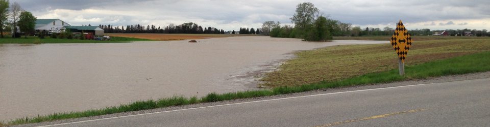
– High forecasted precipitation amounts in the McGregor Creek and Indian Creek watersheds is expected to result in flooding adjacent to the watercourses within their respective floodplains.

– Full operation of the McGregor Creek Diversion Channel is expected to divert flood waters around the City of Chatham.

– Strong northeast winds and waves late this afternoon and overnight could cause blockages of creek outlets along the Rose Beach Line area resulting in flooding as well as cause shoreline damage along Lake Erie.


Environment Canada has issued a Special Weather Statement for our entire watershed due to significant amounts of additional rainfall over the next 24 hours. Over the last 24 hours, our watershed has received between 10 and 30 mm of precipitation. Over the next 24 hours, Environment Canada expects an additional 30 to 50 mm of rainfall. The ground is quite saturated due to the recent rainfall and won’t allow much additional rainfall to infiltrate. Should the forecasted rainfall amounts appear, there will likely be issues of localized flooding due to the amount of rainfall.

Water levels on the region’s smaller local watercourses will continue to rise. Some areas could see overbank flooding. People should take extra caution and avoid the river, ditches, and streams. The combination of slippery banks and fast moving water can be dangerous. Standing water can also present its own unseen hazards. Children and pets should be kept away from the water.

Water levels on the Thames River are not expected to come up much due to the forecasted rains but they are expected to rise. LTVCA officials will continue to monitor the situation and update this advisory if necessary.

Indian Creek and McGregor Creeks:

McGregor Creek peaked approximately 2.9 m (9.5’) above its base level just before midnight last night from the previous rainfall. While it has dropped by about 0.3 m in the last 10 hours, it is expected to begin to rise later today due to today’s higher forecasted rainfall. Indian Creek peaked last evening approximately 1.4 m (4.5’) above its base level and has dropped approximately 0.2 m (8 inches) in the last 12 hours. It, too, is expected to begin to rise again later today due to today’s higher forecasted rainfall.

Because of this, the LTVCA expects it will be necessary to close the dam at the head of the McGregor Creek Diversion Channel to fully redirect flood waters from the McGregor Creek watershed around the City of Chatham to the Thames River. Only water from the Indian Creek watershed will be allowed to pass through the City of Chatham. Officials will assess the situation to ensure the dam closure occurs at an optimal time but expect it to be later today. LTVCA officials will continue to monitor the situation and update this advisory if necessary.

Lake Erie Shoreline (Rose Beach Line, Coho Street, and Bates Line):

Weather forecasts are calling for strong winds late this afternoon and into the early morning on Friday. Sustained northeast winds between 35 and 45 km/hour are expected later this afternoon before switching from the north and diminishing. Sustained wind speeds are expected to peak this evening around 45 km/hour with gusts up to 66 km/hour. Environment Canada’s Marine Forecast has a Strong Wind Warning in effect for our region of Lake Erie and suggests that wind over Lake Erie could reach sustained speeds of 55 km/hour this evening with wave heights building to three metres (10’) late this afternoon. Waves are expected to subside to one metre Friday morning.

Given the wind speeds and direction, it is expected that creeks and municipal drainage outlets in the Rose Beach Line area of Chatham-Kent may become dammed with sand being pushed up onto the shoreline. There is a chance of possible localized flooding associated with the blocked outlets (including over Rose Beach Line, Coho Street, and Bates Line). Residents in vulnerable areas along the Lake Erie shoreline should pay attention to local conditions and prepare accordingly.

People should take extra caution and avoid the shoreline should conditions get rough. The waves can be strong and the shoreline slippery. There could also be hazardous debris within the waves and water which could be thrown onto the shoreline. Standing water can also present unseen hazards. Children, pets and livestock should be kept away from the water. Officials will continue to monitor the situation and update this advisory if necessary.

Share
Find out more information about the LTVCA and COVID-19 COVID-19 Update

Facebook

What’s New?

  • Conservation Ontario Announces New General Manager
  • LTVCA Administration Office Closed Afternoon of Friday July 15, 2022
  • Happy Canada Day!
  • Field Trips Running Full Steam Ahead! Outdoor Education Programming Bustling Once Again at Ska-Nah-Doht Village and Longwoods Road Conservation Area!
  • Spring has Sprung! Big “O” Birding Event Held in Comber

Partner Links

  • Conservation Ontario
  • Thames-Sydenham & Region Source Protection Area
  • Thames River Clear Water Revival

Connect with us!

Search

© 2022 · Lower Thames Valley Conservation Authority |[email protected] | Tel: 519-354-7310

  • Home
  • Privacy
  • Contact Us
Prev Next