• About Us
    • Vision / Mission Statement
    • About the LTVCA
    • Budget and Financial Statements
    • Board Meeting Packages and Minutes
    • Employment
    • Public Events have been cancelled due to COVID-19 Pandemic
    • FAQ’s
    • Volunteers
    • Fees & Publications
    • What’s New?
    • Public Social Media Policy
  • Planning & Regs
    • Plan Input and Review
    • Regulations
  • Water Management
    • Flood Forecasting and Warning
    • LTVCA’s Flood Control Program
    • Water Control Structures
    • The History of Flooding
    • Flood Notices
    • Flood Notice Types
    • Water Levels
  • Education Programs
    • Education Field Trip Programs
    • Non-School Group Programs
  • Conservation Areas
    • 2021 Parking Pass
    • Conservation Area Day Use & Camping Fees
    • Camping
    • Longwoods Road Conservation Area / Ska-Nah-Doht Village & Museum
      • Trail Features and Challenges
    • Big Bend Conservation Area
    • C.M. Wilson Conservation Area
    • E.M. Warwick Conservation Area
    • All Conservation Areas
  • Conservation Services
    • Tree Planting
    • Grants for Landowners
    • Feature Partnerships & Restoration Projects
    • Soil Health
    • Pollinator Habitats
    • Species at Risk
    • Invasive Species
    • McGregor and Jeannettes Creek Phosphorus Reduction Program
  • Foundation
    • About the LTVC Foundation
    • Carey Carolinian Arboretum and Trail
    • Lower Thames Valley Conservation Foundation Bursary
    • Save the Cabins
    • Memorial Forest Program
    • Fund-Raiser
    • Donate to Conservation
    • Volunteer Directors and Members
    • Ontario Trillium Foundation Capital Grant for Wheelchair Accessible Boardwalk Replacement at Longwoods Road CA
    • Trillium ‘Seed’ Grant – Longwoods Feasibility Study 2018-2019
    • Conservation Foundation Privacy Policy
  • Camping
  • Contact Us
  • 2021 LTVCA Parking Passes
15
May

Flood Watch – May 15, 2018 – 11:00 a.m.

Flood Watch – May 15, 2018 – 11:00 a.m.

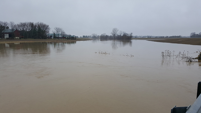
Overnight the Lower Thames watershed experienced intense thunderstorm activity that dropped somewhere between 15 and 50 mm of rain throughout the region. The area south of Chatham received the most rain with over 30 mm of rain recorded at many locations. One rain gauge in south Chatham recorded just over 20 mm of rainfall in a one hour period. Given the heavy rains over the weekend, the ground was not able to absorb much of the rain and most is running off into local ditches and watercourses. There is no more rain of consequence in the 7 day forecast.

Due to the large amount of rainfall within a relatively short time period, localized flooding is occurring. On smaller local watercourses, many are approaching bank full conditions and some have spilled their banks. The McGregor Creek Diversion Channel is operating again to protect the south end of the City of Chatham from flooding. However, Indian Creek that also runs through south Chatham is climbing quickly and isn’t expected to peak until later this afternoon. Water levels on Indian Creek are expected to meet or slightly exceed those observed over the weekend.

Water levels on the Thames River are not expected to come up much from these rains. The Upper watershed received only modest amounts of rain and isn’t contributing significant additional flows to the river.

People should take extra caution and avoid the river, ditches, and streams. The combination of slippery banks and fast moving cold water can be dangerous. Standing water can also present its own unseen hazards. Children, pets and livestock should be kept away from the water.

Officials will continue to monitor the situation and update this advisory if necessary.
This message will be in effect until May 17, 2018.

Contact: Jason Wintermute (jason.wintermute@ltvca.ca, 519-354-7310 x227) regarding this message.

0
SHARES
ShareTweet

Font Size

Zoom in Regular Zoom out

Water Management

  • Flood Forecasting and Warning
  • LTVCA’s Flood Control Program
  • Water Control Structures
  • The History of Flooding
  • Flood Notices
  • Flood Notice Types
  • Water Levels
  • Harmful Algae Blooms

Flood Notice Archives

Downloads

  • Fee Schedule – Conservation Services
  • Personal Flood Emergency Plans

Recent Posts

  • Breaking Ground – 16 acres of Land Restoration is underway
  • Flood Warning – Erie Shore Drive – January 13, 2021 – 10:15 AM
  • Flood Watch – Lake Erie shoreline, Erie Shore Dr. – January 12, 2021 – 12:30 PM
  • Shoreline Condition Statement – Flood Outlook – Lake Erie Shoreline, Erie Shore Dr. – January 11, 2021 – 10:30 AM

Upcoming Events

  • No events

Partner Links

  • Conservation Ontario
  • Thames-Sydenham & Region Source Protection Area
  • Thames River Clear Water Revival

Search


Chatham-Kent and Lambton Children's Water Festival


Canadian Heritage Rivers


A member of
Conservation Ontario

Copyright 2020 · Lower Thames Valley Conservation Authority
  • /Home
  • /Site Map
  • /Contact Us