• About Us
    • Vision / Mission Statement
    • About the LTVCA
    • Budget and Financial Statements
    • Board Meeting Packages and Minutes
    • Employment
    • Public Events have been cancelled due to COVID-19 Pandemic
    • FAQ’s
    • Volunteers
    • Fees & Publications
    • What’s New?
    • Public Social Media Policy
  • Planning & Regs
    • Plan Input and Review
    • Regulations
  • Water Management
    • Flood Forecasting and Warning
    • LTVCA’s Flood Control Program
    • Water Control Structures
    • The History of Flooding
    • Flood Notices
    • Flood Notice Types
    • Water Levels
  • Education Programs
    • Education Field Trip Programs
    • Non-School Group Programs
  • Conservation Areas
    • 2021 Parking Pass
    • Conservation Area Day Use & Camping Fees
    • Camping
    • Longwoods Road Conservation Area / Ska-Nah-Doht Village & Museum
      • Trail Features and Challenges
    • Big Bend Conservation Area
    • C.M. Wilson Conservation Area
    • E.M. Warwick Conservation Area
    • All Conservation Areas
  • Conservation Services
    • Tree Planting
    • Grants for Landowners
    • Feature Partnerships & Restoration Projects
    • Soil Health
    • Pollinator Habitats
    • Species at Risk
    • Invasive Species
    • McGregor and Jeannettes Creek Phosphorus Reduction Program
  • Foundation
    • About the LTVC Foundation
    • Carey Carolinian Arboretum and Trail
    • Lower Thames Valley Conservation Foundation Bursary
    • Save the Cabins
    • Memorial Forest Program
    • Fund-Raiser
    • Donate to Conservation
    • Volunteer Directors and Members
    • Ontario Trillium Foundation Capital Grant for Wheelchair Accessible Boardwalk Replacement at Longwoods Road CA
    • Trillium ‘Seed’ Grant – Longwoods Feasibility Study 2018-2019
    • Conservation Foundation Privacy Policy
  • Camping
  • Contact Us
  • 2021 LTVCA Parking Passes
29
Jun

Flood Watch – Lake Erie Shoreline – June 29th, 2017 – 12:45 p.m.

Flood Watch – Lake Erie Shoreline – June 29th, 2017 – 12:45 p.m.

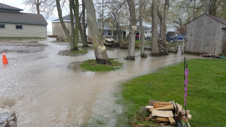
There is currently lakeshore flooding along Erie Shore Drive in Chatham-Kent.  Chatham-Kent municipal staff are responding to the flooding.  Erie Shore Drive may be closed to traffic this afternoon. 

Southerly winds are driving waves onto our Lake Erie shoreline in Chatham-Kent and Elgin County. There is a risk that wave action could damage shoreline protection works and cause shoreline erosion.  The flooding along Erie Shore Drive is being caused by waves crashing against the shoreline protection spraying water up onto the land.  The same effect could occur along other areas of the Lake Erie Shoreline causing localized flooding.   Residents along the Lake Erie shoreline should be prepared. 

Weather forecasts and local weather gauges suggest that the Lake Erie shoreline in the Lower Thames is currently experiencing sustained winds of 30 to 40 km/hr from the southwest with gusts up to 55 km/hr.  Weather forecasts suggest that the winds can be expected to stay like this throughout the afternoon until they being to diminish late this evening and overnight.  Winds are expected to increase Friday morning again to speeds only slightly below what they are now.  Environment Canada’s Marine Forecasts are predicting wave heights on Lake Erie to be around 1m, diminishing to 0.5m overnight.  Water levels at Erieau are approximately 20cm below the record high monthly averages of 1986, similar to where they’ve been for the last few months.

Residents should pay attention to weather forecasts and predicted winds over the next few days.

People should take extra caution and avoid the shoreline.  The waves can be strong and the shoreline slippery.  There could also be hazardous debris within the waves and water.  Standing water can also present its own unseen hazards.  Children, pets and livestock should be kept away from the water.

Officials will continue to monitor the situation and update this advisory if necessary.

This message will be in effect until July 1st, 2017.

Contact:  Jason Wintermute (519-354-7310 x227, jason.wintermute@ltvca.ca) regarding this message.

0
SHARES
ShareTweet

Font Size

Zoom in Regular Zoom out

Conservation Services

  • Tree Planting
  • Grants for Landowners
  • Feature Partnerships & Restoration Projects
  • Soil Health
  • Species at Risk
  • Invasive Species
  • Pollinator Habitats
  • McGregor and Jeannettes Creek Phosphorus Reduction Program

LTVCA Program Forms

  • Agricultural Improvement Fund Application Form
  • Tree Species Price List
  • MJCPRP Application Form
  • MJCPRP Claim Form
  • MJCPRP Pamphlet

Recent Posts

  • Shoreline Condition Statement – Flood Outlook – Standing Message – Lake Erie & Lake St. Clair – High Static Water Level – April 2021
  • Offices Closed Good Friday, Easter Monday
  • Shoreline Condition Statement – Flood Outlook – Lake Erie Shoreline, Erie Shore Dr. – March 30, 2021 – 10:00 AM
  • Shoreline Condition Statement – Flood Outlook – Lake Erie & Lake St. Clair Shoreline, Erie Shore Dr., Lighthouse Cove – March 28, 2021 – 9:30 AM

Upcoming Events

  • No events

Partner Links

  • Conservation Ontario
  • Thames-Sydenham & Region Source Protection Area
  • Thames River Clear Water Revival

Search


Chatham-Kent and Lambton Children's Water Festival


Canadian Heritage Rivers


A member of
Conservation Ontario

Copyright 2020 · Lower Thames Valley Conservation Authority
  • /Home
  • /Site Map
  • /Contact Us