• About Us
    • Vision / Mission Statement
    • About the LTVCA
    • Budget and Financial Statements
    • Board Meeting Packages and Minutes
    • Employment
    • Public Events have been cancelled due to COVID-19 Pandemic
    • FAQ’s
    • Volunteers
    • Fees & Publications
    • What’s New?
    • Public Social Media Policy
  • Planning & Regs
    • Plan Input and Review
    • Regulations
  • Water Management
    • Flood Forecasting and Warning
    • LTVCA’s Flood Control Program
    • Water Control Structures
    • The History of Flooding
    • Flood Notices
    • Flood Notice Types
    • Water Levels
  • Education Programs
    • Education Field Trip Programs
    • Non-School Group Programs
  • Conservation Areas
    • 2021 Parking Pass
    • Conservation Area Day Use & Camping Fees
    • Camping
    • Longwoods Road Conservation Area / Ska-Nah-Doht Village & Museum
      • Trail Features and Challenges
    • Big Bend Conservation Area
    • C.M. Wilson Conservation Area
    • E.M. Warwick Conservation Area
    • All Conservation Areas
  • Conservation Services
    • Tree Planting
    • Grants for Landowners
    • Feature Partnerships & Restoration Projects
    • Soil Health
    • Pollinator Habitats
    • Species at Risk
    • Invasive Species
    • McGregor and Jeannettes Creek Phosphorus Reduction Program
  • Foundation
    • About the LTVC Foundation
    • Carey Carolinian Arboretum and Trail
    • Lower Thames Valley Conservation Foundation Bursary
    • Save the Cabins
    • Memorial Forest Program
    • Fund-Raiser
    • Donate to Conservation
    • Volunteer Directors and Members
    • Ontario Trillium Foundation Capital Grant for Wheelchair Accessible Boardwalk Replacement at Longwoods Road CA
    • Trillium ‘Seed’ Grant – Longwoods Feasibility Study 2018-2019
    • Conservation Foundation Privacy Policy
  • Camping
  • Contact Us
  • 2021 LTVCA Parking Passes
7
Feb

Flood Warning (update) – February 7, 2019 – 5:15 p.m.

Flood Warning (update) – February 7, 2019 – 5:15 p.m.

Highlights:

• The ice jam at Prairie Siding has begun to move.
• Water levels have started to drop in the city of Chatham but may not continue to do so if the ice jam reforms further downstream.
• Buildings within the community still remain flooded
• Flooding as a result of ice jamming can be very unpredictable.

Message:

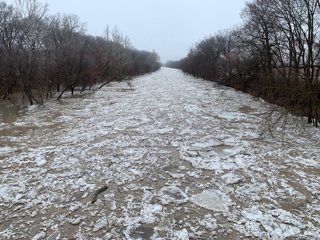
Last night an ice jam formed downstream of the city of Chatham around Prairie Siding. It caused water levels in the city to rise rapidly through the night and have continued to rise all day. Reports have come in that the ice jam has now started to move.

Flooding will still continue in a number of low lying areas within the city of Chatham. Citizens should be cautious as the ice jam may reform further downstream.

There could still be additional impacts along the downstream portions of the river through the Raleigh and Dover areas and into the town of Lakeshore including Lighthouse Cove. Residents should pay close attention to local conditions and be prepared should water levels exceed the flood protections.

The LTVCA continues to operating the 6th Street Dam and Pumping Station. This should protect the south end of the city of Chatham on McGregor Creek from flooding. However, residents in the south end of the city of Chatham should also pay attention to local conditions. A system of thunderstorms is moving through the area, mostly south of us. As water levels are high, excessive rainfall could lead to localized flooding upstream in the areas along McGregor and Indian Creek currently protected by the 6th Street Dam.

People should take extra caution and avoid the river, ditches, and streams. The combination of slippery banks, broken or unstable ice and fast moving cold water can be dangerous. Standing water can also present its own unseen hazards. Children and pets and livestock should be kept away from the water.

Officials will continue to monitor the situation and update this advisory if necessary.

This message will be in effect until February 10th, 2019.

Contact: LTVCA Administration Office (519-354-7310) regarding this message. After hours number 519-351-2240.

0
SHARES
ShareTweet

Font Size

Zoom in Regular Zoom out

Water Management

  • Flood Forecasting and Warning
  • LTVCA’s Flood Control Program
  • Water Control Structures
  • The History of Flooding
  • Flood Notices
  • Flood Notice Types
  • Water Levels
  • Harmful Algae Blooms

Flood Notice Archives

Downloads

  • Fee Schedule – Conservation Services
  • Personal Flood Emergency Plans

Recent Posts

  • Flood Warning – Erie Shore Drive – January 13, 2021 – 10:15 AM
  • Flood Watch – Lake Erie shoreline, Erie Shore Dr. – January 12, 2021 – 12:30 PM
  • Shoreline Condition Statement – Flood Outlook – Lake Erie Shoreline, Erie Shore Dr. – January 11, 2021 – 10:30 AM
  • Shoreline Condition Statement – Flood Outlook – Standing Message – Lake Erie & Lake St. Clair – High Static Water Level – January 2021

Upcoming Events

  • No events

Partner Links

  • Conservation Ontario
  • Thames-Sydenham & Region Source Protection Area
  • Thames River Clear Water Revival

Search


Chatham-Kent and Lambton Children's Water Festival


Canadian Heritage Rivers


A member of
Conservation Ontario

Copyright 2020 · Lower Thames Valley Conservation Authority
  • /Home
  • /Site Map
  • /Contact Us